Despite being confronted with the full force and influence of Woodside and its bedfellows, dissenting communities are fighting might with right. Woodside Vs The Goodside
Agenda - Ordinary Meeting of the Broome Council Council 30 September 2010 Page 63
9.3.8 PLANNING APPROVAL – DRILL PADS, ‘TURKEY NEST’ DAMS AND TRANSPORTABLE ACCOMMODATION – LOT 259 JAMES PRICES POINT, DAMPIER PENINSULA LOCATION/ ADDRESS: Lot No 259 James Prices Point
APPLICANT: Woodside Energy Ltd on behalf of the State of Western
Australia
FILE: DAM/259.LNG
AUTHOR: Manager Planning Services
CONTRIBUTOR/S: Lankester Planning Services on behalf of Woodside
Energy Ltd
RESPONSIBLE OFFICER: Director Development Services
DISCLOSURE OF ANY INTEREST: Nil
DATE RECEIVED: 16 September 2010
SUMMARY: Woodside Energy Ltd proposes to develop three (3) Drill Pad sites, two (2)
Turkey Nest Dams and provide transportable accommodation for a workforce to undertake hydrogeological investigations for a temporary period being a minimum of three (3) months and up to a maximum period of nine (9) months. This is part of the investigations and surveys associated with the proposed Browse LNG Precinct at James Prices Point. The hydrogeological investigations will involve drilling boreholes on the drill pad site to assess the availability of a reliable ground water supply for the proposed LNG plant and facilities. The turkey nest dams will store water pumped from the bore holes and the transportable buildings will provide accommodation for the workforce to undertake the investigations on a 24 hours basis.
The item is brought to Council for consideration as the land falls within the Shire of Broome’s Interim Development Order No 4 (IDO4).
It is recommended that Council support the development.
Site and Surrounds
James Price Point is located approximately 60 kilometres north of Broome. The site on which Woodside intend to construct the drill pad sites and turkey nest dams is approximately 4.5km south of James Prices Point and 1.5km east of the Manari Road and east of the existing Meteorological Tower onsite, which was approved by Council in October 2009. The location falls within the proposed Browse LNG Development site. The land comprises natural vegetation, which consists of eucalyptus and acacia woodlands
See Attachment 1: Location Map
Description of the Proposal
It is proposed to construct three Drill Pad sites, two Turkey Nest Dams and Accommodation for the drilling workforce – these are required for the hydrogeological investigations being undertaken onsite. These investigations will assess the availability of reliable groundwater supplies for the proposed LNG Precinct, which will be used for the processing facilities, potable water for the workforce and/or low salinity water for construction activities, such as compaction and dust suppression. The Department of Water requires Woodside to undertake and to produce a hydrogeological model to support a future application for a licence to ‘take water’ for the purpose of the water supply for the proposed LNG Precinct.
Woodside propose to undertake hydrogeological investigations over a minimum period of 3 months and up to a maximum of 9 months, commencing mid October 2010
The proposal includes the following:
• Clearing a 5m wide access track, approximately 1.5km in length, eastwards from Manari Road to establish the Drill Pad sites and Turkey Nest Dams.
• The Drill Pads are situated approximately 200metres apart and located on the north side of the access track and the Two ‘Turkey Nest’ Dams are within 50m – 200m of the Drill Pad sites and situated on the south side of the access track.
Three Drill Pad Sites
• The vegetation is cleared and topsoil removed to establish three Drill Pad sites, each with an area of 70 metres x 70 metres, which will accommodate a drilling area of 50m x 55m, surrounded by a 1.8m high cyclone mesh fence or galvanized steel fence with locked gates. The Fencing is proposed for security, public safety and fauna protection. A 5m –10m wide firebreak surrounds the drilling area. The Drill Pad sites will also stockpile the topsoil and mulched vegetation, which will be used to revegetate the site at the conclusion of the drilling.
• Drilling will target two aquifers - the ‘Broome Sandstone’ and the ‘Wallal Sandstone’. A third aquifer (the Grant Group) may be drilled however, this option is considered unlikely. The investigations will include water quality, quantity, water temperature and rate of water flow and drilling will continue for 24 hours a day.
• One or two mobile drilling rigs will be used to drill bores holes within each of the three Drill Pad sites. Up to two Drill Pad sites will be operative for drilling at any one time. Associated mobile drilling equipment, one or two workshop/sea containers water tanks, and fuel storage tanks, with associated bunding, will be located temporarily on a Drill Pad site within the fenced area during the drilling operations.
‘Turkey Nest’ Dams
• Each dam is identified within an area of 180 metres x180 metres and within this area; a dam of approximately 125 metres x 150 metres will be created by clearing the vegetation and excavating to approximately 5m in depth with the excavated soil used to create the dam embankments. The site is relatively flat, however any elevated ground will be used to facilitate the dam walls.
• Vegetation which is removed from the area of the dam will be mulched and stockpiled beside the dam and will be used to revegetate the site when the dam is removed.
• Each dam will be fenced with a 1.8m high cyclone mesh fence or galvanized steel fence with locked gates. Fencing is proposed for security, public safety and fauna protection.
• The water produced during the test pumping from the bores will be collected in the Turkey Nest dam/s. The dam/s will be lined with an impermeable layer to ensure that any saline water produced from the bores will be collected in the dam/s and not contaminate the shallow freshwater aquifer. Alternatively any freshwater encountered in the bores may be discharged into nearby creek lines or surrounding bush.
• One dam is required, however depending upon the rate of flow and water quality during drilling, it may be necessary to construct a second dam. Two sites are identified for the dams and planning approval is sought for both dams.
• Transportable Buildings for the workforce Accommodation
• Transportable buildings will be used to accommodate up to 25 persons associated with the drilling which will operate on a shift basis over a 24 hour period. The onsite accommodation will avoid extended travelling to and from Broome for the workforce and will address occupation, health and safety issues for the workers. The transportable buildings - Accommodation/sleeping rooms, Ablution facilities – toilets, showers, wash basins, laundry, ‘Mess’ facilities – kitchen, dining and a Recreation block – will be appropriately cyclone rated and secured with appropriate footings. The specific details of transportable buildings will be provided at the building licence stage.
• The Transportable buildings will be established on a Drill Pad site, when the pad site is not in use for drilling. The buildings will be periodically relocated to an alternate Drill Pad site as drilling operations move between the three Drill Pad sites.
• The accommodation site will be fully serviced with power from a generator, water from the ‘potable water’ bore established as part of the drilling activities and/or from water trucked from Broome, waste water will be collected into holding tanks onsite, rubbish collected and removed from the site, and fire fighting equipment for the accommodation and the drilling activities.
Attachment 2: - Submission “Turkey Nest’ Dams, ‘Drill Pad Sites” and Onsite Workforce
Accommodation
Planning Provisions
The land is included in Interim Development Order No 4 and therefore Council approval is required.
This is what real direct action looks like! For almost 3 months now, the Yawuru Traditional Owners and members of the Broome community have been blockading Buru Energy's proposed fracking sites in the Kimberley. It's time Buru Energy gets the message and fracks off!
The shares appear to have been marked down as traders have bailed out of many stocks regardless of fundamentals, desperate to lock in any profit for fear of it evaporating.
Up 200%, but down 50% in the last year
Buru shares have trebled since early 2011, but are down a whopping 50% over the past 12 months, making the company the second worst oil and gas sector company in the S&P / ASX 200 Index (Index:^AXJO) (ASX:XJO) over the past year.
Big Holes everywhere
Running Scared -
THIS IS NOT WHAT WE WANT FOR ONE OF THE LAST GREAT WILDERNESS LEFT IN THE WORLD
Premier Colin Barnett was quick to talk up the Canning Basin’s shale gas potential when Woodside walked away from an onshore gas plant at James Price Point, saying it was inevitable those resources would be exploited.
While he has pointed to the US shale boom, industry experts say the Canning Basin has a different geology and is unlikely to replicate the same level of success.
Western Australia is on the brink of an explosion in gas fracking activity. Fracking has already begun in some of our most beautiful, fertile, and special places – the Kimberley, our famed Wildflower region, and the Carnarvon food bowl.
If industry and the Department of Mines and Petroleum get their way, then WA will have a US-style ‘fracking frenzy’, with tens of thousands of wells over our farms and the landscapes we love.
The Government must ensure that we’re protected from this industry that threatens our air, water and land.
Scientists, farmers and communities across Australia have expressed concern about the impact of fracking on both our health and the environment – but the Government has ignored community concern and pushed fracking proposals through without proper environmental assessment.
We want the WA Government to follow New South Wales, and countries like France and Germany, and adopt a moratorium on fracking to protect our land and water.
http://cleanwaterhealthyland.org.au/node/148882
Our Local Paper, full page
The Red Hand is everywhere
It is incumbent upon us as members of society to have honest and open conversation about what we do know and what we don't know, what the risks are or may be, and what our strategy for confronting those risks or mitigating those risks will be.
Unfortunately, the conversation is a little too shrill, and a little too cast in the context of extremes, and I think this continues to inhibit meaningful progress and meaningful discussion about what we need to do about what lies ahead.
I may be repeating myself here, but the basic physics of greenhouse warming are very straightforward. The data we have make it very clear that the earth is warming. The data and the physics make it very clear that the bulk of the warming is being caused by human activity.
Objections to fracking
DEMOCRACY FOR SALE
As former ICAC Commissioner David Ipp told Linton Besser:
"One begins to fear that corruption might be far more widespread than was at first thought."
The now retired Commissioner is not the only one concerned. Besser interviews former top NSW bureaucrat Kerry Schott, who resisted corrupting influences only to find herself the subject of spurious corruption allegations.
We also hear from former Premier Kristina Keneally, respected Labor Senator John Faulkner, and Liberal Senator Bill Heffernan, who helped blow the whistle on corruption eating into his own party.
Warning about the dangers in the current system, he says:
"The most important qualification in public life, is not to have a price... every now and then you've got to have a cleanout, and at the present time there's a bit of a cleanout going on."
Significantly, there is no Federal commission to fight corruption. The key questions now are how far will the clean up go and is there the political will to reform the regulations that govern political donations?
DEMOCRACY FOR SALE, reported by Linton Besser and presented by Kerry O'Brien, goes to air on Monday 23rd June at 8.30pm on ABC1. It is replayed on Tuesday 24th June at 11.00am and 11.35pm. It can also be seen on ABC News 24 on Saturday at 8.00pm, ABC iview and at abc.net.au/4corners.
State governments have spent nearly $18 billion supporting mining and energy companies over the past six years, The Australia Institute says.
The research body has published a new paper called Mining the Age of Entitlement: State Government Assistance to the Minerals and Fossil Fuel Sector.
This is the first time anyone has attempted to put a dollar figure on the value of state government assistance to fossil fuel and mining companies across the country.
It shows the bulk of such assistance - via subsidies,concessions and cheap access to infrastructure - has occurred in Queensland and Western Australia.
Foreign Minister Julie Bishop warned last week that Australia would lead international talks in November on reducing ''inefficient'' subsidies to the global oil industry, saying fossil fuel subsidies were distorting energy markets and encouraging ''wasteful consumption''.
The institute's paper, to be published on Tuesday, shows that since 2008-09, the Queensland government has provided more than $9.5 billion in direct support to mining and energy companies, while the Western Australia government has provided more than $6.2 billion.
A huge win for the #Muckaty community! After 7 long years fighting a proposed radioactive waste dump on their country, and a landmark court case, the government has announced that plans for the dump will not proceed. Thanks to the amazing work of the Muckaty community and supporting groups including ACF, the Beyond Nuclear Initiative, Arid Lands Environment Centre, Environment Centre NT, Friends of the Earth Australia, trade unions and the Public Health Association of Australia, the government has dumped the dump! Well done to everyone involved!
The Abbott Government last night passed a bill through the Lower House to hand federal environmental approval powers to the states, ignoring the World Heritage Committee’s concern about this environmentally disastrous plan.
“UNESCO is currently meeting to decide whether to downgrade the Great Barrier Reef’s World Heritage status to ‘In Danger’ and has expressed concern about the Abbott Government’s hasty handover of federal approval powers to the states,” Senator Larissa Waters, Australian Greens environment spokesperson, said.
“But Tony Abbott is ignoring this international expert concern and forging ahead with his plan to give state premiers the final say over destructive projects threatening our World Heritage Areas and threatened species.
“Leaving the fate of the Great Barrier Reef in the hands of Campbell ‘we’re in the coal business’ Newman would put this already struggling World Heritage Area in grave danger.
“Federal environmental approval powers have been in place for more than 30 years and saved the Reef from being scarred with oil rigs in the Bjelke-Petersen era.
“With Tony Abbott’s bill to put the states or even local governments in charge, environmental standards would drop and the fox would be in charge of the hen house Senator Waters said.
SHIT CREEK PADDLES FOR SALE
THE RICH GET RICHER ON OUR RESOURSES
The richest 1% of Australians now own the same wealth as the bottom 60%, according to a new report designed to bolster the case for global and domestic action to shrink the gap between rich and poor.
The Oxfam Australia report also indicated that the nation’s nine richest individuals had a net worth of US$54.8bn, which was more than the combined bottom 20% of the population, or 4.54m people.
The report, released on Monday, follows previous warnings by Oxfam International that the 85 richest people in the world now own the same as half of the world’s population, or 3.5bn people.
“Income inequality in Australia has been on the rise since the mid-1990s, despite all sections of Australian society experiencing some increase in income during the same period,” the report said.
“In 1995, Australia had an average level of inequality compared to other wealthy OECD member countries. Today, we are below average, having become less equal than our peers despite having a better-performing economy than most.”
WE PAY FOR THESE BOYS TOYS
Over the next 30 years or so, we will spend a hair-raising $24 billion on 75 F-35s, even though no Australian-badged fighter aircraft has fired a shot in anger since the Korean War.
The Australian and Western Australian governments have agreed to a strategic assessment to find a suitable site for a liquefied natural gas precinct to service the Browse Basin gas reserves off the Kimberley coast, and to ensure that this site is appropriately managed.
3 INDEPENDENT DELEGATES have been appointed by the WA EPA to do a Environmental Impact Assessment of James Price Point for use as a Common User Hub.
The chairman of the assessors is Jarrad Ealy.
This is a strategic assessment and they have been given no deadline to complete the assessment.
TAKE HEART
For everyone across Australia fighting invasive gasfields and the devastation of coal mining, the Northern Rivers has shown us that the community can prevail. Take heart and courage.
Dear Red,
My name is Meg, I'm a landholder from Bentley in northern NSW.
The NSW Government is threatening to send in up to 1,000 police on Monday next week to break up the peaceful community protection camp defending our valley and to provide access by force for gas company Metgasco.
Would you get on the phone TODAY and ask Premier Mike Baird to go gently at Bentley? Phone him on (02) 9228 5239
We know unconventional gas drilling is unsafe and is a serious threat to our health, our water and our livelihoods. Just last year, a gas well that Metgasco drilled caused a major safety incident where 200 metres of steel pipe exploded into the air and methane leaked out through the well casing.
That's why I'm spending today in Sydney at NSW Parliament House with my husband and neighbours, talking to every politician we can find, and asking them to call off the police action and to protect our valley from gas drilling.
Staff in Premier Mike Baird's office are taking the names of everyone that calls in about Bentley and we have no doubt that your call will affect the decision the Premier makes.
We can't miss this incredible chance to have our voices heard. Please call the office of the Premier now and ask him to go gently at Bentley - phone (02) 9228 5239. Ask him to withdraw police support for Metgasco and respect the wishes of the community at Bentley for a Gasfield Free future.
Please let him know that you would prefer to see the $8 million they plan to spend on the NSW Police operation at Bentley spent instead on hospitals and schools. Let him know that you are concerned the operation will lead to police shortages in high crime areas across the state.
The generous support of the thousands of people who have joined the Bentley camp has inspired me and given me great hope. I am so incredibly grateful for all the support we've received.
That's why I have no doubt that if we all take that next step today, and call the Premier's Office directly, that we can succeed in our goal to protect our valley and our region.
If you have a minute, please listen to this beautiful song written by Luke Vassella, 'Gently Bentley.' It captures everything we love most about our community and our region, and we hope that you can pass this spirit on to Premier Baird when you call him today.
Meg Nielsen, Bentley 2480
PS. To keep up to date on the Bentley situation over the next few critical days, please like and follow the Lock the Gate Facebook page.
PSS. To contribute to the campaign to support communities at risk of unsafe drilling around Australia, please consider becoming a Gate Keeper today.
In todays Broome Advertiser the dunce Procter whinging about companies leaving town because of the "blow-in hippie rabble of well heeled greenies from Sydney's north shore" have scared them all off by stopping the JPP LNG disaster from happening.
Hahaha according to Coleman Woodside spent "almost $2 billion to get James Price Point to work. I don't know how people can expect companies to spend any more money than that trying to make a development commercially viable.
"James Price Point simply didn't work. Period. So talking about local content in the context of a project that won't get built is kind of a hollow discussion."
SO what's Proctor banging on about?
Well him and his spouse Bloom set up an "oil and gas consultancy" that promoted the LNG plant and trumpeted it to the high heavens and back.
Of course there wasn't a well informed analyst anywhere on the planet that believed the plant at JPP would proceed.
The Shire followed Proctors advice to the tune of $8 million and have zero to show for it.
SO Proctor is pissed that the "blow-in hippie rabble of well heeled greenies from Sydney's north shore" know more about building LNG plants than him or his partner Bloom.
How embarrassing!
And worse - the rabble of greenies gave the Shire all the "good oil" on exactly what would happen to the doomed plant FOR FREE !
If that wasn't embarrassing enough the Proctor/Bloom grand plan for Chinatown has come unstuck as their mate designed it all in Japanese by mistake. This was rumoured to cost $4million.(I'm guessing this one as there seems to be a news blackout on the details and according to the Advertiser some time back that was the plan).
It was said at the time "why pay some dickhead from bloody Austria or somewhere $4 million to design Chinatown when the Chinese community would have gladly given suggestions for free?"
HOW MUCH LONGER MUST WE PUT UP WITH "DUMB AND DUMBER"?
Redhand:
Thanks for this great comment and would just like to remind Proctor/Bloom that if Woodside had gone ahead they would have sunk their corporation and Broome would have gone down with them.
Woodside chief Peter Coleman said "We invested about 4.5 million man hours and had hundreds of Woodsiders who dedicated years trying to come up with a way to make this land-based development commercially viable," Woodside vice-president Roger Martin wrote in an opinion piece inThe West Australiannewspaper. "When the final number came in at more than $80 billion, it was obvious these efforts were in vain. " Martin said that modelling showed Woodside’s share of developing the project was estimated at $25 billion, almost as much as the whole market value of the company. "Effectively, we would have spent almost the entire value of our company on an uneconomic project," he wrote.
For the Big Man & Family
The Kimberley is not for shale
Want to know more about fracking in the Kimberley? Want to be part of the campaign to inform our Kimberley community about the dangers of fracking - come along and get informed at a 2 hour presentation: listen to the other side of the story of fracking and take action now. Come along this Wednesday to Broome's Lottery House from 6.30 pm - 8.30 pm. Bring a friend, bring your family. See you there. Thanks mitch torres
Environment Committee to visit Broome as part of Frackimg Inquiry
As part of its ongoing inquiry into the implications for WA of hydraulic fracturing for unconventional gas, the Standing Committee on Environment and Public Affairs will visit Broome on 24'' and 25'' March to meet with stakeholders and discuss how fracking will affect the Kimberley.
The Committee is scheduled to meet with Yawuru traditional owners, Environs Kimberley, the Shire of Broome and also with Buru Energy regarding its upcoming plans to frack its exploratory well sites in the region.
Media inquiries can be addressed to Hon SImon O'Brien MLC, Chairman on 0407 190 541. Other inquiries should be addressed to committee staff on 9222 7300.
“voice of no confidence”
The emergence of March in March is both a hopeful story for progressive Australia and a phenomenon that the right ridicules at its peril. Abbott had reached a hundred days in office, and discontent at the rapid pace of policy change from a coalition that had promised “no surprises, no excuses” was fermenting.
To Family and Friends,
The funeral date has been decided for the 21st of March at 3 o'clock, under the Tamarind tree at Dora Street. If you would like to say something, all is welcome. Let Keels know if you do want to speak so we can make a running order. Please keep your tribute to a few minutes. If you wish to send a tribute, please email it to kimberleyprotectors@hotmail.com before the 12th March. The Daughters are putting a book together including all of of the tributes and a selection of photos from the years gone past. We hope to complete this by the end of next week. So feel free to email anything you would like included.
"All animals are equal but some animals are more equal than others"...Animal Farm
Refusal to accept global warming is driven by corporates: Seumas Milne, The Guardian,
When it comes to the incompatibility of effective action of averting climate disaster with their own neoliberal ideology, the deniers are absolutely right. In the words of Nicholas Stern's 2006 report, climate change is "the greatest market failure the world has ever seen".
The intervention, regulation, taxation, social ownership, redistribution and global co-operation needed to slash carbon emissions and build a sustainable economy for the future is clearly incompatible with a broken economic model based on untrammelled self-interest and the corporate free-for-all that created the crisis in the first place. Given the scale of the threat, the choice for the rest of us could not be more obvious.
Abbott wants to “unlock” old growth forest to make a quick buck…
The Feral RAbbot, digging now holes
Thats for sure
Australia’s treatment of asylum seekers sent to offshore processing centers is cruel, inhuman and degrading and it violates international law, the United Nations’ human rights office said Friday.
It called for an investigation and punishment of those responsible for an outbreak of violence at a center in Papua New Guinea that houses asylum seekers sent there after trying to get to Australia.
Clashes between inmates and guards at the Manus Island processing center in Papua New Guinea this week left one person dead and 77 injured. Ravina Shamdasani, a spokeswoman for the United Nations human rights office in Geneva, noted reports that private security guards employed at the Manus Island center were involved in the violence and added that “states maintain their human rights obligations when they privatize delivery of services such as security, and must take steps to investigate, redress and punish human rights abuses by third parties.” Prime Minister Tony Abbott elected in 2013 partly on the promise of a tough policy toward migrants and asylum seekers, said the government would not succumb to “moral blackmail” and would ensure that the camps were run “fairly, if necessary, firmly.”
Buru Share are drilled down.
Oil and gas explorer Buru Energy has been pummelled on the market after releasing a drilling result from its Ungani oil field in Western Australia’s Kimberley region that casts doubt both on production targets at the Canning Basin field and on the potential of lookalike prospects nearby.
Buru Energy and their international masters Mitsubishi thought they were very clever when they stole the word Buru, an local Yawuru word for Country. However, all they did was casted a very bad omen over themselves.
Thanks to leaked TPP chapters, we know exactly what the “free trade” agreement would mean for the e
Profits at any cost
To anyone who drinks water, the rusted, leaky underground tanks storing underground fuel are the “single largest threat” to its safety. To major oil companies, they’re an opportunity to profit.
Reuters has an exclusive report on the despicable fraud being carried out by Big Oil. Call it “double-dipping”: When toxic, potentially carcinogenic leaks of gas and diesel threaten aquifers, the companies accept government funds to clean it up. Then, they apply for a second payout from the insurance companies. And all the big guys, it seems, are going for it: Chevron, Exxon, ConocoPhillips and Sunoco have agreed to settlements over the past three years totaling over $105 million.
Broome Say NO
For those who don’t know – In short - Fracking is the process of drilling then injecting fluid, much of it toxic, into the ground at high pressure, to fracture gas-bearing rocks to release natural gas.
During this process, methane gas and toxic chemicals can leak from wells and contaminate nearby groundwater. Broome draws its drinking water from the ground. Buru Energy have plans to frack the Kimberley. The US, there have been more than 1000 documented cases of water contamination near areas of gas drilling.
Some of the countries that have banned fracking are France, Bulgaria and Northern Ireland. The Australian state of Victoria currently has a moratorium on fracking.
Here in WA the state Government fully supports fracking.
This Australian Gas Conference on TUESDAY 25TH FEBRUARY will have state ministers from all across Australia. If your fighting CSG in WA, QLD, NSW, SA, NT, VIC this is the event for you.
WE WILL SHOW THEM ALL, WE WILL NOT ALLOW DIRTY CSG/SHALE GAS TO DESTROY OUR LANDS... Event Info;
This Australian Gas Conference on TUESDAY 25TH FEBRUARY will have state ministers from all across A
WA Fracking Inquire
"What we know from other parts of the world is industry best practice means contaminated ground water, serious air pollution, health impacts on communities and serious environmental disturbance, so we don't think industry best practice is going to be acceptable here for Western Australia," he said.
Mr Verstegen said the council estimated there could be 100,000 wells drilled in the Kimberley in the north of the state when commercial shale gas production gets underway based on well density in the US.
But he said the figure may be out by "50 per cent".
Entitlements Are Over
Dont Dump
Guru Buru
Thought of the day
Water, but not a drop to drink
A new study by the Potsdam Institute for Climate Impact Research, published in the journal Proceedings of the National Academy of Sciences, found that climate change is likely to put 40 percent more people worldwide at risk of absolute water scarcity, due to changes in rainfall and evaporation.
FRACKING HELL
WITH RESPECT
TPP
Heard of the Trans Pacific Partnership (TPP)? It’s a highly secretive and expansive free trade agreement between twelve countries -- including the United States, Canada, Mexico, New Zealand and Australia -- that could undermine our democracy. Leaked text reveals that the TPP would empower corporations to directly sue governments over laws and policies that corporate power alleges reduce their profits. Legislation designed to address climate change, curb fossil fuel expansion and reduce air pollution could all be subject to attack as a result of the TPP. Next weekend ministers are meeting in Singapore to sign the deal, but public outrage has some governments reconsidering their support for the agreement. In Australia, New Zealand, USA, Peru, Malaysia, Vietnam and Singapore, citizens have taken to the streets in protest. Last year, 130 members of US Congress voiced their concerns. Opposition is growing stronger, and people-power has been waking up our leaders. Let’s amplify the voices of those fighting this dirty deal and push governments on the fence to withdraw their support: Click here to tell governments to reject the Trans Pacific Partnership. Check this infographic to get a sense of how threatening the TPP is:
A hollow discussion
"It's not an either or situation," Mr Coleman said yesterday. "It's not a situation of choosing James Price Point versus floating.
"We spent almost $2 billion to get James Price Point to work. I don't know how people can expect companies to spend any more money than that trying to make a development commercially viable.
"James Price Point simply didn't work. Period. So talking about local content in the context of a project that won't get built is kind of a hollow discussion."
Smacked in the back of the head
Inclusive
A MUST SEE:Switch your TV on !! NITV Oct 23rd, 8.30pm. Broome and the campaign on TV this Wednesday
https://www.facebook.com/BroomeNoGas
What they said
With a victory confirmed for Abbott, congratulations and gentle reminders to get on with the job have been pouring in thick and fast.
“A focus on reducing the cost of doing business and increasing exploration activity need to be a priority for the Coalition government in order to enable the continued growth of the resources sector in Western Australia,” Chamber of Minerals and Energy of WA chief executive Reg Howard-Smith said.
His Queensland counterpart expressed similar sentiments, adding that Abbott should not buy into an environmental scare campaign being waged over the Great Barrier Reef.
“Now the campaign is over, the work begins to put policy rubber on the road and the Abbott government can be assured of the support and encouragement of the QRC and its members,” Queensland Resources Council CEO Michael Roche said.
The Australian Mines and Metals Association insisted that Abbott had a clear mandate to implement sweeping change, urging him to use his power for the betterment of the resources sector.
“The Abbott government has a clear mandate to restore confidence back into Australia’s resource industry and back into our country as a globally competitive and productive place to do business,” AMMA CEO Steve Knott said.
“We encourage the Coalition to hit the ground running and begin implementing a policy framework that will both attract investment into new resources exploration and also ensure Australia reaps the benefits of a strong production and export phase.”
Just had phone conversation with Nigel Grazia, (Head Office, Woodside, Broome). Was told that in about a month’s time contractors will be mobilised to the James Price Point area to rehabilitate the site of their previous works (‘the grid’ as it came to be known). These rehabilitation works will include removal of ‘most’ of the water bores, ripping and revegetation of existing tracks and removal of the tower, fencing and all associated structures. All up about a few weeks work. Shane Hughes.
The consequences of the James Price Point decision on other projects
This case puts a spot light on past, present and future assessment practices and raises questions about the certainty of decision-making in Western Australia.
For the Browse LNG Precinct (if this is to be further pursued by the State, given the Premier's recent statement apologising for the Precinct's failure), it's back to square one. The EPA will have to completely reassess the proposal (without the involvement of the conflicted members and arguably without the involvement of the Chairman).
For the EPA, it's back to basics. This decision may trigger a wholesale review of EPA practices (not just those in respect to conflict of interest).
As a result, proponents who have proposals in the pipeline may find the process delayed as the EPA sorts itself out. Even those proponents with a fresh approval in their hands might find that they are subject to challenge. Either way, they will need to be prepared for what might turn out to be lengthy and expensive delays in their approval process, and be more vigilant to ensure similar mistakes don't vitiate any future approvals.
Clive Hamilton, an Australian public intellectual and author of several books on climate change, wrote:
“To environment groups it’s been apparent for some years that the traditional methods of campaigning have been woefully inadequate in securing a political response anywhere nearly proportionate to the threat posed by global warming. For those open to the implications of the scientific warnings, a sense of despair can take over when they see once again the failure of governments to protect the future wellbeing of their citizens and the extraordinary power fossil fuel corporations exercise over government decisions.”
Welcome back to Broome Champions! Richard Hunter, Terence Hunter, Ketrina Keely and Vivienne Oshea with family and supporters outside Broome airport, after returning from Perth and victory in the Supreme Court!
The case also demonstrates that the States cannot be trusted to protect their own natural heritage and that the Federal Government needs to maintain an environmental oversight, the Wilderness said adding that this ruling sets a bold precedent and is a stark reminder of why final environmental approval powers should not be left in the hands of the States.
Mr Barnett described the ruling as "regrettable'' - and signalled the government would fight on.
"The decision relates to the process ... he did not in any way question the environmental conditions or approvals themselves,'' Mr Barnett said.
"All the environmental evidence and surveys and research has been done over many, many years. I am confident that still stands.
"It is now simply up to the state government to resubmit the environmental evidence and the recommendations on conditions attached to the use of James Price Point. That is, in all likelihood, what we will do.''
We know that shadowy forces are always trying to undermine our efforts in the most disgusting, but ultimately futile ways. All over the world police, main stream media and corporate security agents are either trying to infiltrating or undermining opposition movements in order to protect the rich and powerful. However, we have seen in so many countries recently people power and the pursuit of truth and justice is unstoppable, even faced with the most repressive and unacceptable Stasi-like tactics
What are the different types of compulsory acquisition?
The Native Title Act makes different rules for two different types of compulsory acquisition these have a quite different impact on native title:
Where the Right to Negotiate applies – Compulsory Acquisition for third parties, often mining or development companies
Under Government acquisitions for other people, like mining companies or developers the law provides that the parties have certain rights including the right to negotiate.
The right to negotiate is when the Native Title Act requires that the parties (which will include the State and the developer) have to negotiate in good faith with the native title holders with a view to reaching an agreement.
Under these processes the parties; the State and the Miner or Developer and the native title party (which is the Applicant in a registered native title claim) have a certain amount of time to reach an agreement on deciding how the if the act can be done, and what conditions can be imposed.
If the parties cannot reach agreement in six months then the question of if the act can proceed, which in this case is the compulsory acquisition of the land, can then be made by the National Native Title Tribunal.
Where the Right to Negotiate does not apply – Compulsory Acquisition for Government purposes.
Compulsory acquisition for the Government purposes – this is generally when the Government takes land to use for Government purposes, which are often called public works. In this case the native title holders are provided with less rights and the right to negotiate will not apply to the compulsory acquisition.
UPDATE : The Wilderness Society WA and Goolarabooloo law boss Richard Hunter were involved in hearings in the WA Supreme Court onJune 4-5th , which placed the spotlight directly on the controversial processes which led to the recommendation for environmental approval from the EPA and then the WA government. The main issues contested were the Environmental Protection Authority's (EPA's) approval on these three main points: The EPA should have considered options aside from James Price Point; The conflicted members of the EPA Board should have been excluded from the assessment processes long before they finally were, and non-conflicted experts empanelled to assess the proposal when the conflicts were first identified, and The EPA Chairman, Doctor Paul Vogel should not have made the final decision as a 'board of one'. WA'sChief Justice Wayne Martin presided over the case, and will deliver his verdict late July or early August. We are positive about how the case went and have our fingers crossed, so watch this space to hear news of the outcome
Commenting on the State Agreement, Buru’s Executive Director, Mr Eric Streitberg, said:
“We welcome and endorse the Premier’s comments that “this legislation will bring about the continued exploration for natural gas in the Canning Basin, the development of a gas pipeline to the Pilbara, and ensure Western Australian consumers have first use of any gas discovered”.
Buru is undertaking a systematic and comprehensive exploration and appraisal program in the Canning Basin and has identified both a large gas resource which is the focus of the State Agreement, and a significant oilfield at Ungani which is currently under development. We look forward to continuing to develop these resources to bring value to all the stakeholders involved in the project.”
We are delighted to release our latest movie and invite you to join us for the launch at sun pictures on Saturday the 15 starting with a stunning slide show of Kimberley Images at 6 pm.This is a celebration of the wonders of the Kimberley. Hope you can all make it. Kind Regards Richard and Annabelle
The legal team has wrapped up proceedings in Western Australia's Supreme Court against the EPA's environmental approval process of Woodside's gas hub at James Price Point.
Even though the development was canned by Woodside, this case is still extremely important in holding the EPA to account in what we argued was a massive conflict of interest.
The Judge will hand down his decision in a couple of weeks, and whatever the outcome, we're proud to have stood up for the environment and Indigenous heritage.
(Left-right) Dr. Hanes Schoombe, Peter Robertson, Simon Millman, James Johnson, Heidi Nore, Vivienne O'Shea, Katrina Kealy, Richard Hunter and Terri Hunter Jnr.
Photo: Patrick pearl man (EDO)
The Wilderness Society and Goolarabooloo Traditional Custodian Richard Hunter are continuing their legal challenge against the WA Environment Minister and the Environment Protection Authority (EPA) over the way the gas hub was approved.
Their initial reaction was to ‘adjourn’ (put on hold) the Supreme Court case since Woodside’s decision meant there was no chance of a development there for the foreseeable future.
However, the WA state government has insisted the case be heard NOW, in order to secure approvals and access for the JPP site so they can still use it for a potential supply base for offshore gas operations and refinery for onshore shale gas from the canning Basin.
The landmark case will therefore be heard by the Chief Justice of the WA Supreme Court from June 4-6. A month of deliberation before a decision is made is likely.
The carbon budget deficit
Between 60-80% of coal, oil and gas reserves of publicly listed companies are ‘unburnable’ if the world is to have a chance of not exceeding global warming of 2°C
The total coal, oil and gas reserves listed on the world’s stock exchanges equals 762GtCO2 – approximately a quarter of the world’s total reserves;
If you apply the same proportion to the global carbon budgets to have an 80% chance of limiting global warming to 2°C, their allocation of the carbon budget is between 125GtCO2 and 225GtCO2, illustrating the scale of ‘unburnable carbon’;
come along to the Divers Tavern from 6.30pm on Thursday May 9th, to say thanks to yourself and everyone else involved in getting the Campaign to where it is today. ntry $20 if you have a job, $10 if you don't, all proceeds to help pay outstanding legal fees associated with the Campaign.
More details to be posted when they are finalised.
HAPPY EARTH DAY
Seven of the world's 12 LNG projects are now under construction in Australia, and by 2018 production would approach 90 million tonnes a year.
Browsing the winners
energynewsbulletin
Within minutes of the formal announcement from Woodside on Friday, the value of the company soared by more than $1.1 billion, a number derived by calculating the value of the company before than announcement and the peak share price on Friday.
For the statistically alert the actual numbers were a pre-cancellation Woodside share price of $35.28 and a Friday peak price of $36.70, with the extra $1.42 being applied to the company’s 823.9 million shares on issue.
While seemingly meaningless to anyone outside the investment world that price difference represented a $1.1 billion gift to Woodside shareholders. In The Slug’s book an extra billion dollars is the definition of a winner.
What remains to be seen is whether Woodside management will take the next step and actually share some of the extra wealth generated by mothballing Browse through a share buyback or special dividend.
Brian Monk JPP is a beacon for the world, you took on the biggest and sent them running, you exposed corruption, bias, a whole range of rotting trash. Well done, enjoy your victory and spread it accross the world. People need to protect culturally significant regions, and also protect a future. The corrupt governments both elected and public officials need to be exposed, it is up to us to throw this corruption out of the world while we have a sustainable future left. I like the mantra, waylay and delay, educate and mobilise, stop the project. Well done, I am in awe.
WOODSIDE, its joint-venture partners and the Barnett government are "morally obliged" to pay out a $1.5 billion social benefits package attached to the aborted plan for a gas hub north of Broome.
With this level of speculation the ASX would want a statement of some sort. Woodside have stated that Peter Coleman will be making a statement in the morning.
However will be watching the ASX tomorrow.
The link is : http://www.asx.com.au/
type in WPL and then Recent announcements.
Woodside have a Board meeting on April 22, two days before the AGM. “They are under a lot of pressure to provide definitive statements to the AGM, especially as they will be under the blowtorch from shareholders and the media scrum over what’s going to happen with the gas hub. They know they will want answers. They may well ask for an extension or they may well provide definitive statements.”
Taken from Finding Beauty in a Broken World by Terry Tempest Williams (2008)
“I’ve been thinking about words, individual words and the language we use when talking about nature, how lnaguage shapes perceptions. A word enters my mind: “hypography” - \hi-pah-grah-fee\ n: 1) any public lands given over to corporate interests at the public’s expense; 2) landscape once pristine, now abused by grazing, clear cuts, strip mines, toxic waste dumps, or oil and gas development; a state of extreme corruption fueled by bureaucrats.”
My name is Rodney Augustine.
I am a Jabirr Jabirr - Nyul Nyul and Ngambal Man. The songline of this country runs in my veins. My liyan is same as my elders liyan... this feeling is always with me. I can feel them walking on country.
The thought of woodside going on our old people’s graves makes me want to put my life on the line. I want to bring everyone around the world to stand on country so we can stop woodside and the only way I could think of bringing the peoples energy there was with this NO GAS event.
It might sound stupid but the people intentions and feelings put together can make us strong. Some people don’t understand that, but I believe it’s true. My Lyian tells me some of my people have been deceived in believing we have no choice but to sell out.
Woodside has brought division and trouble in our community and our families. This makes me feel very heavy inside. There is other ways to move forward without destroying our country.
If woodside and Mr Barnett are allowed to continue their illegal mining on our land. Our culture our country and our environment will be extinct. My Lyian tells me to stand up for country.
And that is what I am doing. This is too important for all us countrymen. You know it and other countrymen know it too. We can’t run away from it. it’s in us. We are suppose to protect country!! that’s our job!! I will never sign over my culture and my existence , for no amount of money. Money can’t buy me! Rodney Augustine Wocky
Flawed Gas Hub Development Steamroller Continues to Flatten Local
Recently re-elected Greens WA Member for the Mining and Pastoral Region Robin Chapple MLC has expressed dismay at last night’s turn of events in the James Price Point saga.
“I am deeply saddened that yet again, the people of Broome have been pushed to breaking point by the heavy-handed tactics of the Barnett-Grylls government, as shown by the public disturbance reported at yesterday’s meeting of the Kimberley Joint Development Assessment Panel,” Mr Chapple said.
“It’s no wonder some people react bitterly, when they see their democratically elected Council sidelined by these unrepresentative bodies.“The Government should take heed of yesterday’s fracas, because it is surely but a precursor to what will happen around the state, as more and more vital decisions affecting people’s day-to-day lives are taken out of their hands and given to so-called “experts”, with locally elected citizens in the minority.
“In this instance, we have the laughable proposition that it is somehow OK to drop a Fly-in Fly-out (FIFO) camp for nearly 1,000 workers into the middle of an “Agricultural” zoned area adjoining small rural properties where people are pursuing organic horticultural activities.
“Unfortunately, we shouldn’t be surprised, as the whole James Price Point venture has clearly been flawed from the outset and only continues today thanks to the blinkered, fanatical determination of the Premier,” Mr Chapple concluded.
State and society are distinct interactive and dynamic entities. The state focuses on governance and institution building; society’s cultures and needs are more diverse.
These are the dynamics we see at play in the Kimberley as Colin Barnett moves into his second term as Premier.
Professor Flannery said in a statement that it was critical for emergency and health services, as well as the public, to have the best information from scientists.
''Ignoring it or shooting the messenger will not reduce the threat of climate change, it will just mean that Australia is less prepared,'' he said. ''We'd be living in the past to think that Australia did not need to prepare for a changing climate.''
Professor Flannery, a palaeontologist and author who was Australian of the Year in 2007, has been seen as a polarising figure by some because of his calls to phase out large-scale use of fossil fuels.
Photo Damian Kelly
Palaeontologist, Dr Steve Salisbury from the University of Queensland, Goolarabooloo Lawman, Richard Hunter and Scientist and former Australian of the year Tim Flannery on the Goolorabooloo coast early morning over Easter examining dinosaur footprints in collaboration with Broome Dinosaur Trackers.
A Climate Commission report released on Wednesday examined links between Australia's extreme weather and human-induced climate change. It found natural events were being influenced by climate change, because greenhouse gases are accumulating and trapping extra energy in the Earth's atmosphere and oceans.
Commenting on the $1.3 billion benefits package that traditional owners were bound to receive for giving consent to Woodside and the State government’s LNG Precinct development project, Professor Pat Dodson, Broome Yawuru elder, told ABC Radio National's 360:
"Just a lot of rearrangement of public sector funding. Most of it is just a rearrangement of what governments would be required to outlay if they’re going to address the inequities that are already in existence. I have a difficulty as a citizen having to go and beg for a government to provide me with the services that I require to have an equality of life in my own Country."
Stopping James Price Point proposed LNG greenfield would be a major step towards stopping large scale destruction of the environment and distortion of the Kimberley economy and the erosion of our democracy.
We are all concerned about the social and economic issues faced by indigenous communities. We all accept the need to tackle the continuing profound and shameful legacy of hundreds of years of dispossession, denial and despair but we do not accept that the best way to close the gap is by digging a deeper hole, poising the water and polluting the air.
Australia can and must forge a future that embraces indigenous cultural and ecological knowledge and heritage and takes a different approach to managing our precious country for all generations to come - and we believe this is a journey that must be taken together.
The state government is trying to block moves by Aboriginal families to lodge a claim on land earmarked for the Kimberley gas hub in a bid to hold together its land deal.
The families who signed off on the 1.5 billion dollar deal to give up land at James Price Point for an LNG precinct remain divided over whether it should proceed. They’ve applied to the Federal Court to abandon their joint native title claim so those for and against the project can lodge rival claims over the land. The state government and Woodside have lodged objections to this in a bid to hold the land deal together. In its submission the government has asked to have the court hearing adjourned past the 18th of April, which is the deadline for new native title claims to be lodged. If successful the move would block opponents like Joseph Roe from gaining negotiation rights.
FIX THE GATE, LOCK THE KEY BUT YOU WILL NEVER TAKE MY COUNTRY
Kimberley Protectors:- Woodside on Country earlier today repairing gate at compound entrance, Manari Rd, and putting up new gate out back at the Biota Track. They've now left Country.
TODAY, Two Police officers in unmarked vehicle visited Walmadany Tent Embassy. Past experience tells us, plans are being made by police to do the bidding of the state by providing protection for corporate interests and alienating the community. EXPECT INVASION SOON. Time to plan, pack your bags and get back into Country to protect the dunes and established support camps. Broome people if you see large equipment, dongas, drill rigs, medical centre donga, barge movements etc, either in Broome or on the Highway, pls txt 0487 604 679 or 0415 998 007. Also, establish your own gas information network on your own phone and social media networks to ensure maximum flow of information and support.
Red Hand has heard that the Woodside people who have been out in Country this week have been setting electronic equipment in Country. All of this is in their preparations to start their destructive drilling program in a few short weeks. All trackers are ask to investigate AND IF devises are located, remove. What ever Woodside do to try and stop us from protecting community, country and culture will be to no avail. They will need to remove our hearts if they wish to stop us.
Supporters old and new : we can't stress enough how important it is to print off, get signatures and post back to us the attached petition. Okay, so it's going to cost you a 60 cent stamp but you've supported the campaign for a reason : to protect Walmadany (JPP). Please help and return signed pages as soon as they're complete - no need to wait until you have 5 sheets :) Looking forward to reams and reams of petition sheets to arrive soon! Thanks a million friends. PS please share.
ALERT : expect Woodside equipment and trucks soon. Look out for don gas, medical centre, fencing, drill rigs, earthmoving gear, extra personnel etc either in town or on way to Broome. Txt info (ONLY TXT) 0487 604 679 or 0415 998 007.
Global temperatures are warmer than at any time in at least 4,000 years, scientists reported Thursday, and over the coming decades are likely to surpass levels not seen on the planet since before the last ice age. (...) In the new research, published on Friday in the journal Science, scientists compiled the most meticulous reconstruction yet of global temperatures over the past 11,300 years, virtually the entire Holocene. Continue reading: http://alturl.com/fi34x
Our new mapping shows that 437 million hectares of our land is covered by coal and gas licences or applications. That's more than half of Australia and an area 18 times the size of Great Britain. Even our greatest international tourist icons are not safe, with at least 11 of our 16 National Landscapes at threat. Download the high-quality pdf version of this map to view all of the detail and to print it off as poster: https://www.dropbox.com/s/08zsa9hllinrkqw/MAP_AustralianNationalLandscapes.pdf Learn more about our Call to Country campaign, and how you can get involved, here: http://www.calltocountry.org.au/ — in Australia.
Peter Coleman, a compass will surely lead you North, but it cannot tell you of the monsoonal vine thicket, dinosaur track sites, ancient living Songline, the annual journey of the whales, evenings with frolicking bilbies and the strength that is held by a determined education and empowered community. All this stands in your way. I'm paraphrasing Tony Kushner's remarkable screenplay, here, because that single sentence encapsulates one very clear message. Peter, your compass is broken, you are heading in the wrong direction, turn back now before all is lost..
51% Broome Community against Gas
This survey was conducted some time ago, so I believe the figure would be more up to 62% against, given the raised level of education on impacts and awareness of social, environment and economic ramification of this proposal. Red Hand
Transcribed from audio of 7:30 ABC regional news: An independent survey of attitudes to the Kimberley gas hub shows more than half of Broome’s residents oppose the project and 30% are in favour. 359 residents were surveyed for a study of community attitudes commissioned by the Broome shire in late 2011. 51%of respondents described themselves as not supportive of the project and 29% were supportive or strongly supportive. A further 20% were undecided. Shire president graham campbell says the shires decided to make the results public as a result of requests from ratepayers. “Gotta bear in mind this was done some time ago but er’ people will be interested it was a independently run consultation process and survey er’ done and I think it was nearly 400 people surveyed. All the data will be on our web site and I’m sure people will be quite interested to have a look at it.
This was the 7:30 ABC regional news, which differs to the 6:30 am ABC regional news. In the 6:30am version, audio of shire president Campbell is played ... saying “I don’t think people should read too much into this” ?
"In Australia, by law, you only own the top metre. Everything underneath, that is owned by the people of Australia," Peter Strachan, a resources analyst at Perth-based StockAnalysis, said.
"If someone puts in a request to explore on your land, you have to deal with that and make sure you're compensated for access."
Groups seeking access to private land in Western Australia must seek the approval of the Warden's Court, which deals with disputes over and applications for mining leases, and negotiate compensation with the owner.
Exciting news - Dr Bob Brown is coming to Broome next week. There's an opportunity to catch up with him and locals to talk about the future of the Kimberley. How do we create economy that protects our land, sea and provide culturally appropriate employment?.
Bring your family to listen to some music and together establish a positive vision for the future of the Kimberley.
Broome style curries available and cakes.
More details to come.
Facebook entry, name witheld.
Text's a bit hard to read, but this is what I think it says: Woodside is an amoral Australian company with a history of belligerence and insensitivity. We believe that by doing what’s right, we can never perform to our very best. This means living our values every day, which isn’t hard - we don’t have any. The Woodside's Compass provides guidance and direction as we strive to achieve the vision of becoming a global leader in upstream oil, gas and their associated ecological destruction. INTEGRITY We are open, honest and fair. We do what we say we will do. We have the courage to do the right thing. As long as it suits our immediate purposes. You can believe it anyway. RESPECTWe give everyone a fair go, unless it might threaten profitability. We listen. Then we ignore. WORKING SUSTAINABLY We are here for the long term. At least till next quarter’s profit result. We look after each other, our mates that is. Communities and the environment have to be mentioned here somewhere, whatever they are. We keep each other safe, in the board room. WORKING TOGETHER We are on the same team, the Woodside Team. Join us or f!@k off. We build long-term partnerships - we are always on top, you are bent over. DISCIPLINE We play by the rules, which we like changing as the need for profit dictates. Don’t give us government rules though - they suck! We set moving goalposts and we hold ourselves to in our own pockets. EXCELLENCE We achieve great results - just look at that profit result! We learn, especially what your name and address are, and where your kids go to school. We get better, especially at stomping on you. OUR MISSION To deliver superior shareholder returns. Yep, that’s about it really. Nothing else matters, seriously. OUR VISION Our aim is to be a global leader in upstream oil, gas and ecological and societal destruction. OUR STRATEGIC DIRECTION Maintain our leading Australian position by optimising our producing assets and commercialising our growth projects and other premium opportunities. And baffling the likes of you with business-speak. Grow our portfolio by leveraging our core capabilities for global upstream growth. And a bit more baffling. PARTNER OF CHOICE We are the premium choice for partnerships based on our distinctive capabilities, culture and track record as a great partner. As long as we’re on top and you’re bent over. ENGAGED PEOPLE We work for a highly regarded and successful company - it is always on the minds of people in high places. We are part of a team working together for great results and have opportunities to contribute and grow. Everybody wants to be on our team, predictable dummies like Colin Barnett of course, but look - we’ve even coerced the West Australian Police Force! FUNCTIONAL EXCELLENCE We leverage our core-drilling capabilities and the latest fracking technology to create new opportunities and sharpen our competitive edge, driving a wedge into communities, stripping vegetation, and leaving a lasting legacy in our wake. DECISION EFFECTIVENESS We make and execute decisions in line with our business priorities and our values. So get out of our f!!@king way you hippy granny latte-sipping shits and let us get on with rapin’ and pillagin’ like we ought to!
The Gillard Government has stared down union demands to force petroleum giants such as Royal Dutch Shell to process huge gas reserves onshore to boost local jobs, paving the way for the use of floating LNG on Woodside's $40 billion Browse project.
Unions have attacked the Government in recent weeks over the issue, saying FLNG would cost jobs at the expense of overseas shipbuilding yards. They wanted the Government to use its manufacturing support policy, released this week, to force the issue. But the policy did not contain any references to FLNG or other union and industry demands to force petroleum companies to provide cheap gas.
Perth: Concert for the Kimberley : John Butler, Missy Higgins, Ball Park Music, and Dr Bob Brown and more in a celebration one of the most beautiful, unique, and threatened places on Earth. Fremantle Esplanade, WA. Sunday 24th Feb. 1:30-6:30pm. We have heaps of great volunteers willing to help on the day, but we need people to help spread these beautiful posters (right), please contact Sarah or Wazza on (08) 9420 7255 at TWS. Sydney : Festival for the Kimberley; Come and indulge in the total sensory experience of visiting the Kimberley coast – enjoy live music, markets, dancers, speakers, camels, a life-size Kimberley whale and much more. Martin Place, Sydney CBD. Friday 22nd Feb, 2013. Perth: Kimberley starlight films: Hyde Park, Perth CBD. Wednesday 27th Feb, 2013. Join us for an amazing collection of short films produced of the last two years in the Kimberley. Get a snapshot of the amazing culture, Heritage and community campaign to protect the Kimberley. The night will begin with a string quartet, so lock this event in your diary!
Mitch Torres writes "You want to see resistance and people standing up for country, heritage and their burial sites - take a look at this documentary, I went to this site in Montreal with the local indigenous people and saw that their places were still standing - but they supported each other in the face of great opposition from the state and guns. We have forgotten Noonkanbah and the resistance that had people from all over Australia support the Nonkanbah people - where has that solidarity gone? Our old peoples burial sites are about to be threatened with destruction by Woodside and the WA State Government - and we need your help to support us....1st James Price Point (Walmadan) next your country in the middle of the Kimberley along the river countries, tablelands, desert.....I for one do not want to deal with people in the future saying those mob on the coast sold us out - they didn't fight hard enough because you will be looking at another global giant and government cutting your land up and damaging your waterways....let us stand together Kimberley Countrymen and women....when the time comes, when we send out the call we need your support to come and stand with us to protect our special and important places..."
Our children will pay the greatest price for climate change. What will it take to save them? What will you do to protect them? Check out this short video: http://www.youtube.com/watch?v=YwrrikNeFZg&feature=player_embedded
Have you heard about unconventional gas fracking? Don't know what it is or don't think it'll happen in the Kimberley (think again)?
"Without rigorous scientific studies, the gas drillling boom sweeping the world will remain an uncontrolled health experiment on an enormous scale" -Dr Bamberger and Dr Oswald, Cornell University
Guest speakers will include SARAH MOLES (Lock the Gate Alliance) and JAMIE HANSON (Climate and Energy Program, Conservation Council WA) ... ‘Lock the Gate’ are the most successful anti-fracking group in Australia, coordinating the activities of the many inspiring grassroots activists fighting against Coal Seam Gas in Queensland and NSW.
The Clean Water, Healthy Land Speaking Tour will be travelling up the coast of WA, visiting affected communities and offering an opportunity to hear about the gas fracking industry in WA, the risks, and what local communities are doing to keep their water clean and their land healthy.
Cheers, we hope to see you there,
Clean Water, Healthy Land
Social licence is a real and important phenomenon that mining companies must consider in their planning and operational activities. The power of communities, although ultimately limited in regulation is real and impactful in shaping the way mining takes place in Australia. Woodside clearly do not have a social licence.
The difference between the No Gas at James Price Point and other famous campaigns is the fact that most campaigns start when the project is starting. The Broome community campaign has been opposing Woodside long before the project has actually started, meaning that the movement has already great regional, national and international momentum support, spiked with experience and founded in solid determination. No other campaign has ever achieved this type of premeditated community opposition strike. Woodside and the joint venture partners need to make these final investment decision public. We all know the decision has already been made, behind the closed doors. They are all keeping their shareholders on the hook but it would be really wonderful if they could have some compassionate humanity and take the anxiety, uncertainly and distress out of the Broome community by making this announcement public now .
Barnett has invested serious political capital in Oakagee, only to see it fail; what was to be Australia's food bowl the Ord River has become a Chinese sugar bowl; and the James Price Point gas development has been mishandled by his Government and appears ill-fated.
WE NEED YOUR HELP. The court case between The Wilderness Society, Richard Hunter, Goolarabooloo lawman and the EPA was heard in court this morning with Woodside waiting to join the action, which would definitely raise the stakes and costs of the case to challenge the state gas hub approvals.
There were also thousands of pages of legal documents delivered to our Perth office this morning (pictured), which will do doubt provide some light reading for our legal team over the next few weeks.
(Menafn - The Australian Financial Review - ABIX via COMTEX) --Federal Environment Minister Tony Burke says he will not be rushed into making a decision on the approval of Woodside Petroleum's A40bn Browse LNG project. Western Australian Premier Colin Barnett had urged Burke to make a decision before the state election on 9 March 2013. The State Government has approved the project. Burke refused to comment on the specifics of the onshore Browse project, but noted that there are environmental advantages of building offshore LNG plants.
Goolarabooloo Jabirr Jabirr Native Title Claim (WAD6002 of 1998)
The Native Title Claim Group Authorisation Meeting that was held over the last few days decided yesterday to split the Native Title Claim(WAD6002/98). An overwhelming 195-1 voted for Goolarabooloo and Jabirr Jabirr to go their separate ways. The legal ramifications of all the agreements that have been signed to date calls into question their validity. For an agreement to be legally binding it needs to be signed off by the appropriate and true people. Until this is clarified in the Native Title Tribunal neither group has the right to sign anything. What is apparent about this unanimous victory is that the Department of State Development’s outrageous false claims that they have obtained free, prior and informed consent from the rightful Indigenous owners can finally be put to rest. Getting free, prior and informed consent was a major component of the SAR with the Federal Government and also our obligation to the United Nations Declaration on Human Rights.
From The Wilderness Society (WA) What's the first thing you think of when you see this full page Woodside ad in The West? ... yeah, wasn't easy destroying local communities, 60,000 years of living culture and our unique and pristine wilderness, against the peoples' will. What a joke, Woodside.
Research by The Australia Institute suggests that slowing down the pace of coal exports would actually result in enormous benefits to the Australian economy. It would allow our other key export industries – including manufacturing, tourism, education and agriculture – to expand, employing more people and paying more tax.
Because these industries are all far more labour intensive than mining, less subsidised and mostly better taxpayers than mining, it would lead to more jobs and increasing state and federal revenue in the long run.
Jim Yong Kim, the new president of the World Bank, also at Davos, gave a grave warning about the risk of conflicts over natural resources should the forecast of a four-degree global increase above the historical average prove accurate.
"There will be water and food fights everywhere," Kim said as he pledged to make tackling climate change a priority of his five-year term.
Communities affected by extractive operations can learn to articulate their development needs in a way that invites sustainable social investments rather than be bewitched by the prospect of a windfall of cash compensation and philanthropy. The cowboy companies like Woodside can likewise learn that the short-term tactical gains of these money drops come at the much higher cost of long-term strategic value. Windfalls and misdirected philanthropy should not be confused with investing in real long-term human or community development.
La'o Hamutuk has published Cowboys, Ogres and Donors: A Decade of Corporate Social Responsibility in Practice by Mandy White, who represented Woodside in Timor-Leste in 2007-2008. The paper sharply criticizes Woodside's "ogres at the helm" and "sycophantic senior staff" taking a Public Relations approach, "not making even tokenistic efforts" to develop Timor-Leste. Whyte characterizes the company's "blundering arrogance:" "Woodside steadfastly refused to regard the Timor-Leste Government as a partner in the development of the Sunrise fields, seemingly characterising them not only as a 'thorn in the side,' but also as devious and untrustworthy. ... [D]riving forward to a final investment decision without the Timor-Leste Government demonstrates an arrogant lack of regard for the relationship."
Once Again, Red Broome takes the message to Woodside's door in Perth. Sweep them clean OUT OF COUNTRY
The sinkhole in Bayou Corne. Courtesy of Assumption Parish, LA official website.
Geologists and engineers are now facing problems they’ve never had to deal with simultaneously: a sinkhole, plus a widespread leak of both oil and natural gas. No clear roadmap for recovery exists for Bayou Corne, and evacuees still do not know when they will be able to return to their homes.
Jeffrey Sachs, Director of The Earth Institute at Columbia University and Special Advisor to the United Nations Secretary‐General on the Millennium Development
...natural gas is clean, it is cleaner than coal, but it is absolutely not clean enough to divert us from a trajectory of grave damage on the environment — let’s be clear about that. We use rhetoric, which lulls us to complacency, to say that natural gas is a clean energy source. It is not a low-carbon energy source. It’s low-carbon only in comparison to coal. But it is high-carbon in comparison to what our climate can take.”
“Using gas is like smoking a ‘light’ cigarette. It may contain slightly less harmful substances, but it will still kill you.
“Woodside's Section 18 approval of grave disturbing works flies in the face of previous recommendations and Court decisions not to allow mining in the area due to its cultural and environmental significance,” said Mr Chapple.
“I am appalled at the ACMC’s recommendations to permit the works to go ahead. In 1991, the ACMC recommended that no exploration activity should occur in the areas defined at the song cycle path and nothing has occurred to diminish this significance.”
“The ACMC is a toothless tiger that consistently fails to protect sites, and the Aboriginal Affairs Minister (Peter Collier) should be ashamed.” He said the Aboriginal Heritage Act is only “a thin veneer of protection” further weakened since a review last year.
The Law Bosses Mr Roe and Mr Hunter have separate legal fights in the Courts to protect their Country. Mr Hunter is arguing inadequate environmental approvals which if upheld would mean the whole Environmental Protection Authority approval process would have to start from scratch.
If Mr Roe’s court battle is won by him then there may well arise the cause for the Native Title claim to the site to be heard before any works commence.
ACTION OF THE DAY A MAJOR national bank has been forced to remove more than 100 misleading out of order signs from its ATMs after being targeted by anti-coal activists.
A score of ANZ Banking Group machines sprawled across six capital cities were plastered with "out of order" signs on Sunday after campaigners launched their latest bid to draw attention to the bank's funding of the coal industry.
The Climate Commission released this report on Saturday to virtual media silence. The average max temp between Jan 2-8 was 39 degrees! The image below is an important take-hime message. http://climatecommission.gov.au/wp-content/uploads/CC_Jan_2013_Heatwave4.pdf
Jessica Ernst is a scientist who has worked in the oil and gas industry. She discovered first hand the consequences of hydraulic fracturing in her town of Rosebud, Alberta, Canada. Jessica has come to Michigan and to other places around the world to warn communities of the dangers of fracking.
The Goolarabooloo Welcome to Country sign on Manari Road has been damaged either it has been shot at or hit with an axe. Two large gashes in top of sign.
PLEASE NOTE THAT SOMETHING HAS HAPPEN TO THE BLOG AND IT IS CURRENTLY ONLY SHOWING ONE BLOG POST AT A TIME. PLEASE CLICK ON OLDER POSTS TO READ MORE. MEANWHILE, WE ARE WORKING ON FIXING THIS. A LITTLE STRANGE!!!!!!!!!!
We think it worth a fuller account — especially as another recent study shows that Australia’s media has largely failed to connect the January heatwave to climate change. Simon Divecha is the business manager at the Environment Institute of the University of Adelaide. A week ago the website The Conversation published his study which showed that fewer than 10 of the 800 articles published in the previous five days about the heatwave had mentioned climate change, global warning or greenhouse gas.
The most recent Jan 2013 Climate Commission’s report lists what it says are four key messages for Australians arising from the heatwave. They are:
1. The length, extent and severity of the current Australian heatwave is unprecedented.
2. Although Australia has always had heatwaves, hot days and bushfires, climate change is increasing the risk of more frequent and longer heatwaves and more extreme hot days, as well as exacerbating bushfire conditions.
3. Climate change has contributed to making the current extreme heat conditions and bushfires worse.
4. Good community understanding of climate change risks is critical to ensuring appropriate action is taken to reduce greenhouse gas emissions and to put measures in place to prepare for, and to respond to, extreme weather.
Kel Mydas I hope he's in a better mood than he was last night. An appallingly ignorant and arrogant display that simply reinforced the fact that our elected representatives do not want to listen to us. He won't have lost any votes from that group, who would be unlikely to vote Nationals anyway, but I would think local candidate Michelle Pucci might be having a few second thoughts after being so thoroughly embarrassed by her party leader.
Nationals Leader Brendon Grylls on Breakfast this morning defending James Price Point as the best place to process Browse gas, the State election and the seat of the Kimberley and if Royalties for Regions will live if the Lib's win with a majority.
Another letter of response Dear Michelle and Minister Grylls,
I want to thank you both for agreeing to meet us at Lotteries House yesterday.
To be honest this was one of the worst encounters I have experienced with a politician. And there has been lots in the last two years and lots of them were with politicians who were representing the ‘other’ side. I certainly did not go to that meeting hoping we would change your mind Minister Grylls, I was hoping to hear what your party was going to do if was to go ahead and what your ideas were on how to manage the issues arising. Outside of talking about land release to keep the rental prices down I did not hear anything. Instead I witnessed you not answering questions and concerns again and again – just because they didn’t fit into the criteria that you laid down when you first walked in ‘I’m only going to talk about what your concern would be if the gas goes ahead’. Well life doesn’t work that way. You can’t tell people who have lived in this beautiful town for a long time or were born here that they can’t talk about the hurt and trauma they have gone through in the last few years. You may as well rip people hearts out when you tell them ‘You are entitled to leave this town’ after hearing that their very essence is tied to this place, their families, their life, their love.
When I got home I couldn’t sleep for a looooong time. I am suffering from a bad headache this morning. I couldn’t just shrug off the encounter as ‘ah well another politician that wants the gas’. What concerns me more than your position on the gas (and yes you are entitled to that) is that you as a person who is supposed to be representing THE PEOPLE doesn’t know how to listen anymore, doesn’t seem to feel the worry and angst of the people in the room, doesn’t seem to have any compassion, doesn’t even look at people when you talk to them. Is there still a human being in there behind that concrete wall that you have erected around yourself? I worry about where we are going as a nation if the members we have elected as our leaders have lost or buried essential human qualities? I couldn’t help but reflect if you have just reduced yourself to a puppet of the party.
Michelle: I felt sorry for you to be in the presence of Minister Grylls. If you would have been there by yourself a constructive dialogue could have taken place. I felt you know how to connect to people and listen to our concerns. In your political career – wherever it may take you, I really really hope you will never lose that.
In the upcoming elections I won’t vote for you though – sorry Michelle. Obviously the Greens candidate represents my beliefs a lot more here in the Kimberley.
My name is Rodney Augustine. My countrymen know me as Wocky. I am a Jabirr Jabirr, Nyul Nyul and Ngambal Man.
The songline of the Kimberly runs in my veins. It’s the very life force that keeps me alive. I don’t expect you Mr Barnet or Woodside to understand this spiritual and sacred connection to my dreaming. but I’m pleading with you to try to find it in your heart to give us the respect we deserve as human beings. I have always opposed mining on country. I have seen what has happened in the Pilbura. I don't want the same destiny for Walmadany. Why do you Mr Barnet continue to push forward with wanting to kill us countrymen??? Why don’t you understand that as you desecrate our country you are killing our dreaming, our Songline our culture. You are killing me! That’s murder in any law! My Lyian tells me that Woodside has brought only division and trouble in our community and families. This does not feel like a happy future to me.
The Broome community outside Woodside's offices last night standing united. There will be NO GAS!
Please share : TODAY 5.30 outside Woodside offices Coghlan Street, Broome. Candelight vigil to express our outrage DIA S18 approval and to support Goolarabooloo protection of country law and culture. Bring candles
The Minister for Indigenous Affairs has granted Section 18 approval to Woodside to disrupt Aboriginal Heritage sites in the Cultural and spiritual significant sanddunes of James Price Point (Walmandy) According to the Minister the Songline is NOT A SITE.
Thats right, the Songline is not a Site it is made up made up of numerous sites: ceremonial, skeletal material/burial, artifacts and middens.
Woodside have actually applied for two Section 18. The first application that was approved was heard at the November Aboriginal Cultural Material Committee meeting. Another Section 18 application was advertised on the 19 of December and is scheduled to be heard at the ACMC meeting on the 13 of February 2013
The Minister for Indigenous Affairs has granted Section 18 approval to Woodside to disrupt Aboriginal Heritage sites in the Cultural and spiritual significant sanddunes of James Price Point (Walmandy) According to the Minister the Songline is NOT A SITE. That right, the Songline is not a Site it is made up made up of numerous sites: ceremonial, skeletal material/burial, artifacts and middens.
Woodside have actually applied for two Section 18. The first application that was approved was heard at the November Aboriginal Cultural Material Committee meeting. Another Section 18 application was advertised on the 19 of December and is scheduled to be heard at the ACMC meeting on the 13 of February 2013
Not every summer will be hotter than the one before. In fact this year is markedly hotter than the last couple of years when we had relatively milder and wetter conditions.
But what we are going to find on average is more of the hot extremes and faster increases in the future, over the next 10 and 30 years, that we have seen over the last 30 years - more hot extremes, more heatwaves and more extreme fire conditions.
Climate scientists have been talking about these increases for more than 20 years in Australia. We are now seeing exactly what was predicted more than 20 years ago.
Professor David Karoly
The Woodside-operated Browse LNG joint venture underwent considerable restructuring over the course of 2012, with Japan's MIMI paying $2 billion for a 14.7% stake, Shell taking over Chevron's interest via an asset swap, and BHP Billiton selling its 10% to PetroChina for $1.63 billion. BP also holds a minority stake in the project.
Miranda Devine’s columns defending violence against environmentalists set a new low for the editorial standards on the opinion pages of the Daily Telegraph and the Sydney Morning Herald. While media publishers such as Rupert Murdoch’s News Limited and Fairfax Media rightfully complain against the victimisation of journalists by vindicative governments or vigilantes, their willingness to defend or potentially incite harassment of environmentalists exposes how shallow their commitment is to ensuring debate over issues is kept within acceptable bounds.
It is, for example, hard to believe that a column defending or advocating violence against journalists would get a run in either the Daily Telegraph or the Sydney Morning Herald. Imagine the outcry if Devine had written that, after a bashing of a journalist, that “violence has its place”. Or the fury of the journalists union if she had written that “it is not arsonists who should be hanging from lamp-posts but journalists”.
But it seems that for the sake of creating controversy to sell newspapers, Devine’s toxic views defending and potentially inciting violence against environmentalists are tolerated.
When we put these developments against the harsh warnings of an organisation as conservative as the World Bank — that “we’re on track for a 4°C warmer world marked by extreme heat-waves, declining global food stocks, loss of ecosystems and biodiversity, and life-threatening sea level rise” — the only reasonable conclusion is that the world has gone mad.
Australia emits 19 tonnes of carbon dioxide a year for each person who lives here. If the world wants to avoid more than 2C of warming the global average must be below three tonnes a year per person. Our addiction to economic growth is now a clear and serious threat to our long-term future.
Pitt & Sherry economist Phil Harrington, a Hobart-based specialist in climate mitigation and adaptation, discovered how serious when he looked into emissions from the proposed new "clean, green" liquefied natural gas hub at James Price Point, Western Australia.
The WA Government says the gigantic plant will release somewhere between 12 and 39 million tonnes of greenhouse gas a year. Calculations of negative impacts by proponents and their supporters usually prove conservative in practice. The upper limit is probably close to the mark.
Based on this supposition, Harrington did his own sums and came up with the number of rooftop solar systems needed to offset emissions from this single industrial undertaking.
The answer is wait for it 20 million. As Harrington says, it's a pity there are only around eight million households in Australia.
pb@climatetasmania.com.au
Suncorp Group said in its Risky Business report on risk management.
“More frequent extreme weather events, economic growth, urbanisation and population shifts towards high-risk areas have all combined to dramatically increase Australia's risk exposure,” Suncorp said in the report. “The chance that natural hazard will become natural disaster is greater than ever.”
"It does not require a majority to prevail, but rather an irate, tireless minority keen to set brush fires in people's minds." - Samuel Adams
For the first time in history almost all of humanity is politically activated, politically conscious and politically interactive. Global activism is generating a surge in the quest for cultural respect and economic opportunity in a world scarred by memories of colonial or imperial domination.
The internal strife of a nation is not predicated on the transitory moods of its people but the attitude of its government. Revolutions are not waged by happy people in an honorable land. True revolutions are a product of generations of discontent stemming from dishonest and vicious bureaucracy. An establishment government facing a wave of discord from the masses has, in most cases, done something to deserve it. I, like many, do not relish the idea of a national revolt, but if I am to be honest in the face of the facts about fracking, I have to acknowledge that the potential for one within my lifetime is significant. I also can’t say that it is not necessary. Unless tomorrow brings a miraculous shift in current totalitarian govrnement trends, revolution may be all we have left…
Despite today's news of the Wilderness Society and Goolarabooloo traditional custodian Richard Hunter launching legal proceedings against the EPA and Envrionment Minister Bill Marmion over the approval of the controversial James Price Point gas processing complex, Mr Barnett did not seem concerned.
"James Price Point has gone through an exhaustive process and has received environmental approval," he said. "Nothing more to say."
From The Wilderness Society : The EPA has just been Served! The Wilderness Society & law boss Richard Hunter are taking the EPA to court over the conflicts of intrest and the fact that 1 man made the decision to approved James Price Point! Merry Christmas!
before The Hon. The Chief Justice
Mediation Room 1, 17th Floor 111 St Georges Tce Perth
14:15, 18 Dec 2012
Roe v. The State of Western Australia & Ors (CIV 2765/2012)
Strategic Conference
According to the Supreme Court of Western Australia Annual Review of 2011, Strategic Conferences wereestablished as a strategic conference procedure. Commercial and Managed Case list judges hold strategic conferences in almost all cases soon after the defence is filed to provide the parties and the court an opportunity to assess the nature of the case to identify a targeted approach to resolve the case in a less costly and more timely manner.
Although the benefits of the new procedure is yet to be formally assessed, anecdotal evidence suggests it is working. The requirement to have trial counsel involved in the case early has generated sufficient consideration of the case so as to result in settlements in some cases, or streamlined preparation for trial in others.
The WA Supreme Court has been asked to overturn the state government's second attempt at compulsory acquisition of the site and rule the $1.5bn compensation deal negotiated with the Kimberley Land Council invalid.
The action alleges the government facilitated an abuse of the federal court process in its dealings over James Price Point.
The Supreme Court action, on behalf of traditional law boss, Phillip Roe, claims the KLC had been placed under "improper pressure" by the WA government when it threatened the KLC and the applicant of the native title claim over the area if the group proceeded with a court action to split the claim.
The KLC was acting following a vote of Goolarabooloo and Jabirr Jabirr people that the native title claim be split.
The new action alleges the state government's actions had been an abuse of the acquisition processes as well as the Federal Court's claim process.
A summons has been lodged in the WA Supreme court against the State of Western Australia, WA Minister for Land, WA Land Corporation, Broome Port Authority, the Kimberley Land Council and others.
In a statement, Mr Barnett said: "The agreement reached by a vote of traditional owners was in accordance with the Commonwealth Native Title process under the supervision of the Federal Court. The state government is confident it has acted in accordance with this process and that the second Notice of Intention to Take was valid," Mr Barnett said.
LNG WATCH PNG has been launched to raise awareness of the illegalities associated with the signing of the multi-billion dollar PNG LNG project. It was bulldozed through by the PNG Government and the developers. The minority in the signing room were forced to sign, but most of the landowners missed out on signing the agreement. The people of Hela (Landowners) do not understand the PNG LNG project, and what effect it will have on their land and environment. Nobody has properly informed the local landowners about the development's full impact. Hidden, corrupt practices have facilitated the project’s development thus far, the landowners and Papua New Guinea more generally have been overlooked. Some of these secret deals are known, some are not yet known. Therefore, the LNG WATCH PNG is set up to monitor and stop the culprits who claim the PNG LNG project as their sole property. LNG WATCH PNG will also dig deep into the past and watch the future of the PNG LNG Project so that the developers and the PNG government pay proper homage to the PNG LNG owners.
OFF COUNTRY WOULD LIKE TO HIGHLY RECOMMEND THAT THIS IS A BLOG TO FOLLOW IN SUPPORT OF OTHER COUNTRIES, COMMUNITIES, PEOPLE WHO ARE SUFFERING AT THE HANDS OF THESE PARASITIC OIL & GAS CORPORATIONS.
TODAY In Chambers before The Hon. The Chief Justice Court 1, 08:30 Roe v. The State of Western Australia & Ors (CIV 2765/2012) Directions
Floating Browse a cheaper option
Woodside?s Browse LNG project would need oil prices to average more than $US105 a barrel to make an economic return in its current format, strengthening the argument for it to be developed as a floating venture.
The EPA’s assessment failed to properly consider sites for the gas processing plant outside the Kimberley. There were failings in the assessment of whales, dolphins, sawfish, sea turtles, bilbies, dinosaur footprints, monsoon vine thicket and dredging, many of which have been criticised by independent scientists.
No assessment of the social, cultural and economic impacts – as was required by the strategic assessment agreement with the federal government.
Broome to be Inpex supply hub
TOLL Mermaid Logistics Broome, a 50%-owned subsidiary of Mermaid Marine, has won a five-year, $20 million contract to provide supply base services to Inpex in Broome, Western Australia.
Under the contract TMLB will develop dedicated infrastructure and provide various services at its Broome supply base to support Inpex’s Ichthys LNG project development drilling works.
The contract has two five-year extension options.
TMLB, an incorporated joint venture between Mermaid and Toll Holdings, was created in 2006 to provide supply base services in Broome to support offshore activities in the Browse Basin.
The Ichthys gas field is in the Browse Basin off the WA coast.
Macquarie said Australia's five most advanced LNG developments - Pluto (completed) PNG LNG, Gorgon, Queensland Curtis LNG and Gladstone LNG - were already 32 per cent over-budget and six months late despite being only 60 per cent complete.
With construction peaking in 2013, the analysts warned, "the worst may lie ahead".
The analysts said the growing suggestion was that Woodside's Browse LNG development, Australia's largest remaining undeveloped resource, would struggle to yield acceptable returns going to James Price Point, 60 kilometres north of Broome.
The ABC are reporting that state's Opposition Leader Mark McGowan says BHP's decision is not a good sign.
"All the feedback we get is this project won't happen," he said.
"The major cause of that is the Premier interfering and intervening and creating a business environment which is not friendly and that's the outcome, that major investors will pull out."
Latest pro gas bullshit : seen today in Boome is a new black on white sticker “PUT A HUB ON IT”. After some research we found out a whole batch were made in Bali for a local Broome business person.
Pilbara a basket case: Grylls
Gareth Parker, The West Australian
Nationals Leader Brendon Grylls has described the Pilbara as a “basket case” because of government failures to plan for its growth, leaving its 50,000 residents to live with a raw deal.
"It wasn’t planned and then the community has had to put up with what they’ve got and struggle with it,” Mr Grylls said.
I’ve had more people cry in meetings with me in the Pilbara in the past 12 months than I’ve ever had in my full political career. And they’re crying because of the failure of government.
“They’re crying because having rents of $2000 a week when you’re a small business owner means you’re probably going to lose your business because you can’t afford employees.
Labor MLA for Pilbara Tom Stephens, who will retire at the election, said the speech was an admission of failure and instead of contesting the seat Mr Grylls should resign.
“He’s been in the driving seat for four-plus years, with a policy commitment to fix it,” Mr Stephens said.
“He’s blaming everyone for their failures, but he’s a senior Government minister with direct responsibility for land release and regional development.
“He’s become part of the problem, not part of the solution.”
I was push-polled on the topic of the gas hub this evening. It was clearly aimed at Green/conservationist people, advertising itself as being about "social issues" to draw you in. The actual poll was entirely about the gas hub. They went through a long series of questions such as "do you agree/disagree that the hub will revitalise the Broome economy by bringing in new business opportunities", and "do you like/dislike Bob Brown" then at the end finally asked "has this changed your views about the project?"
It was kinda funny actually - by refreshing my memory of many of the issues it actually INCREASED my feelings of opposition to the project by the end!
Mambo Like This Page · Yesterday We would normally never silence our flatulent dog but we felt that this cause was worthwhile. Like Save The Kimberley and support NO GAS in the Kimberley. It's one of the last great wildernesses and it needs your help
At COAG on Friday, the government is scheduled to cement its plans to hand over its powers to protect the environment to state governments. This will give the state governments the power to turn James Price Point into a massive gas hub.
And if you are in WA, help us stand up for James Price Point at this event on Saturday: http://on.fb.me/SFBZvt
MACQUARIE says Woodside will struggle to maintain its BBB+ credit rating if it sticks to current project timelines. Discussing Woodside’s entry into Israel, Macquarie said the cost of the Browse LNG development alone would see its funds from operations versus total debt ratio dip below 35% in the 2019 financial year, possibly triggering a downgrade.
The rise in CO2 concentration and global temperature has continued to closely match the projections over the past five years, while sea level continues to rise faster than anticipated. The latter suggests that the 21st Century sea-level projections of the last two IPCC reports may be systematically biased low. Further support for this concern is provided by the fact that the ice sheets in Greenland and Antarctica are increasingly losing mass (Rignot et al2011, Van den Broeke et al2011), while those IPCC projections assumed that Antarctica will gain enough mass in future to largely compensate mass losses from Greenland. For this reason, an additional contribution ('scaled-up ice sheet discharge') was suggested in the IPCC fourth assessment.
Nov 28, 2012 (The Australian - ABIX via COMTEX News Network) --
The CEO of Woodside Petroleum is reluctant to take sides in a dispute between joint venture partner Shell and the Western Australian Government. Peter Coleman says Woodside is still pricing the development of an LNG facility at James Price Point. Shell believes that an offshore floating LNG plant is the most viable financial option, but these plans have been rejected by the State Government, which is keen to keep the jobs in Australia. The debate is likely to become a highly contentious political issue.
Barnett ups ante on Browse
Kim Christian, AAP
The West Australian Premier has upped the ante on the controversial Browse gas project, indicating that joint venture leader Woodside Petroleum might not receive state government approval for a floating option.
Colin Barnett said he doubted that the cost of constructing his favoured onshore gas processing plant at James Price Point, near Broome, could blow out to between $60 billion and $70 billion, causing Woodside to deem the project uneconomic.
The proposed liquid natural gas (LNG) development at James Price Point goes ahead will be the single largest carbon polluter in Australia, and it will have no requirements to operate efficiently or reduce carbon pollution at all.
At the stroke of a pen Minister for the Environment, Marmion has allowed a staggering 5.5 million tonnes of additional carbon pollution every year for the life of this project – roughly equal to the pollution from an extra 400,000 Australian households.
The EPA recommended a number of requirements for the gas hub to reduce carbon pollution in order to meet Premier Barnett’s commitment to world’s best practice; however Minister Marmion has overturned the advice of the EPA as well as the Appeals Convener in order to reduce costs for Woodside.
Red Finger reports:We are not alone ... we are sooo not alone! This huge poster was photographed today on a billboard on the Royal Perth Hospital building (Lord Street).
THE National Native Title Tribunal has admitted a seniorexecutive failed to declare her ownership of a consulting firm that facilitated access to Aboriginal land by miningcompanies.
Nor did the NNTT’s former West Australian state manager, Lillian Maher, declare her relationship with two employees of Fortescue Metals Group, which benefited from tribunal decisions.
Given the rapid growth of reliance on non-resident workers in the resources sector carries significant impacts for individual workers and their families and host communities, as evidenced by the many submissions to the Australian Parliament House inquiry into FIFO/DIDO work practices, chaired by the Independent MP Tony Windsor. Some of the significant impacts include:
A sudden influx in high risk populations (young single males with large disposable incomes) exacerbating crime and alcohol-related social disorder problems.
The creation of new lucrative unregulated drug markets and markets in commercial sex work.
Rises in traffic congestion and road accidents.
Stretch on infrastructure.
The erosion of community wellbeing.
Heightened risk of protracted social protest over coal-seam gas extraction.
Ongoing widespread social protest against the erection of camps in close proximity to established rural communities.
Increasing burden on local services.
Soaring housing costs and other local costs of living
“Fly over effects” on the local economy, and an ever-decreasing permanent resident workforce
Increasing rates of staff turnover,
Reversal of the trend of women entering the mining industry (down from 15.7 to 12.6% according to the most recent ABS statistics)
Increases in the average hours worked each week exacerbating fatigue related car accidents and work injury as they commute either end of work cycles than in the workplace (an average of hours 45 hours as at August 2011, with 1 in 3 working over 60 hours per week).
These impacts undermine the long-term sustainable community development of Australia. It is troubling therefore that dramatic socio-demographic processes have been unleashed by this boom without concerted attempts to accurately research, measure or account for the numbers of non-resident workers involved and their nation-changing impact on the Australian society and economy.
Within days of the latest court action being lodged, Woodside stopped work at James Price Point, removed all of its machinery and buildings and placed "revegetation site" signs around the area. The company said the site had been prepared for the coming cyclone season but there was still work to do this year.
The Supreme Court current action, on behalf of traditional law boss, Phillip Roe, claims the KLC had been placed under "improper pressure" by the WA government when it threatened the KLC and the applicant of the native title claim over the area if the group proceeded with a court action to split the claim.
The KLC was acting following a vote of Goolarabooloo and Jabirr Jabirr people that the native title claim be split.
Keeping the joint Goolarabooloo Jabirr Jabirr native title claim intact allowed the government to complete a second attempt at compulsory acquisition of the site without having to deal with opponents of the hub.
A first attempt at compulsory acquisition was overturned when the court ruled the state had not adequately identified the area to be acquired.
Broome Community No Gas Campaign
Today and tomorrow this week, 15th and 16th November, Aljazeera TV are in town!! Yes that's right - Aljazeera - the global news network. (check them out at http://www.aljazeera.com/) So the world can see how much opposition there is to the JPP project in our community, please refresh/replace/make new No Gas Hub, Pipe it, Float it, Protect our Heritage banners and signs to decorate your house with.
Oil and gas company Woodside has formally lodged an application to carry out exploration drilling near the Rowley Shoals in the state's North West.
As part of a joint venture with Shell, the company wants to drill eight wells in the search for reserves of oil and gas.
Some of those wells would be 30 kilometres from the marine park.Rowley Shoals lies 300 kilometres west of Broome and is made up of three coral atolls. Nothing is sacred to this corporation, take what you can regardless of the fact that we are all responsible to look after the planet we were born on. Corporation do not have human rights to just help themselves to our shared planet's natural resources.
The days, that corporate greed fosters the destruction of the planet and their insistence that they have the rights of human but none of the responsibility, are numbered.
THE SIGN ON WOODSIDE's MANARI GATE STATES:
Woodside Packing Up & Leaving Country 11th November 11.30am
The current word from the Walmadan Protectors is that Woodside are currently pulling down their compound at James Price Point. Fencing and equipment was removed last night and currently the fence posts that surrounded the compound are being plucked out by an excavator. All equipment out the back of the proposed precinct has all been removed.
A sign has been erected on the (ex) Woodside compound gate, on Manari Road at James Price Point state that the area is now under regeneration.
Fencing materials apparently has all been donated the the local Pony Club. Is the Tower coming down as well?
Woodside are leaving Country.What this all means is anyone guess, but Woodside are packing up and leaving Country. YAYOOOOOOOOOOOOOOOOOOOO. Images will be provided in due course.
Hey, nice that they fixed up the road before pulling the pin!!!!!!!
The Intertidal zone on the west side of the Damiper Peninsula is National Heritage Listed because of the dinosaur track sites embedded in the Broome sand-stone.
However, the National Heritage Council has done nothing to uphold their oblations under the National Heritage management principles (Schedule 5B, EPBC Regulations) for the protection of these important Australian heritage treasures.
Basically, the National Heritage Council has really only drawn a red line on a map and to this day no independently produced map indicating the true boundaries of the intertidal zone, and or the heritage protection areas.
·The objective in managing National Heritage places is to identify, protect, conserve, present and transmit, to all generations, their National Heritage values.
·The management of National Heritage places should:
-Use the best available knowledge, skills and standards for those places, and including ongoing technical and community input to decisions and actions that may have a significant impact on their National Heritage values;
-Respect all heritage values of the place and seek to integrate, where appropriate, any Commonwealth, State, Territory and local government responsibilities for those places;
-Ensure that their use and presentation is consistent with the conservation of their National Heritage values;
-Make timely and appropriate provision for community involvement, especially by people who have a particular interest in, or association with, the place and may be affected by the management of the place;
-Provide for regular monitoring, review and reporting on the conservation of National Heritage values
NONE OF THIS HAS, IS OR EVER WILL BE
UNDERTAKEN, WHY?
Lurujarri Dreaming Community Screening : 19th November 7pm, at Goolari Media Enterprises 7-9 Blackman st..... 4 years in the making, Lurujarri Dreaming is a 27 minute animated documentary about the Lurujarri Heritage Trail, the Goolarabooloo's connection to country and the legacy of Paddy Roe OAM (Lulu). Featuring a film score by Steven and Alan Pigram, and archival recordings of Paddy Roe. The community screening is an outdoor event at Goolari Media Enterprises, refreshments provided, bring blankets/seats. Entry by gold coin donation.
Woodside Petroleum (ASX: WPL) has confirmed that is bidding on the oil and gas rights to an enormous undersea gas field off Israel’s coast.
Woodside Petroleum (ASX: WPL) is taking a 40% stake in a deep water oil and gas exploration block offshore Myanmar from South Korea’s Daewoo international Corporation.
Woodside has joined with partners keen on an exploration licence offshore Cyprus.
You would think that Woodside has enough on its plate already, with its Pluto LNG plant stuck in first gear, after the company was unable to find enough gas to support an expansion.
Woodside also has plans to develop two additional – and controversial – LNG plants, namely Browse and Sunrise. Browse is facing opposition from all levels of main stream society. An LNG processing facilities will do untold damage to the environment and national Cultural heritage values at James Price Point and the Broome community, the Austrlian people are becoming more aware of the issue and the campaign.
Its partners in Browse, including BHP Billiton (ASX: BHP), Shell, MIMI and BP, are clearly all in favor for the gas piped to existing processing plant, or on to a floating one, rather than building a greenfield site at James Price Point.
Sunrise has its own issues. East Timor wants an LNG processing plant built in East Timor, with gas piped to it from the Sunrise gas field, while Woodside has said it prefers a floating processing plant.
A final investment decision by the Woodside-led joint venture on a controversial $40bn development of the Browse LNG project south of James Price Point is due next year.
Tender bids for infrastructure were received in the June quarter and Woodside said a "disciplined assurance process is progressing to determine project costs and economics".
A go-ahead decision has already been delayed from this year and analysts suspect the new date of mid-2013 could also be missed.
Environmental assessment/approval regulation should be considered a hand-brake on the breadth and intensity of impacts, at best. The listing of a species or a heritage site/value doesn't accord protection, it merely brings it within scope of assessment.
The EBPC Act only requires assessment and approval of projects likely to have significant impacts, leaving the cumulative effect of insignificant impacts, the broader effects of environmental impacts outside scope (not matters of national environmental significance), projects not submitted for assessment, and the impacts that are approved (whether mitigated/offset or not) within the discretion of the decision-maker - usually on the basis of poorly defined economic or social benefits - to continue reducing the resilience of our biodiversity, heritage and the environment more generally.
All the platitudes about 'maintaining and enhancing the environment' and 'striking the right balance' contained within the EPBC Act are meaningless if the actual restorative functions provided for in the Act (e.g. recovery planning) are under-resourced and poorly or partially implemented.
As much as it is disturbing to anticipate the States gaining greater autonomy and reduced oversight from the Commonwealth, they'll be inheriting a system that lacks any substantive evidence of its efficacy in protecting the environment.
Answered on 8 September 2011
JAMES PRICE POINT — REGISTERED ABORIGINAL SITES — TERREX REPORT
757. Hon ROBIN CHAPPLE to the Minister for Indigenous Affairs:
I refer to Aboriginal sites at James Price Point.
(1) Is the minister aware of the 1991 WA Museum report prepared by Mr Nicholas Green, then a senior heritage officer with the Western Australian Register of Aboriginal Sites, for the Broome Mining Wardens Court in relation to exploration licences E04/645, EO4/646 and EO4/647, which generally is referred to as the Terrex report?
(2) Is the minister aware of the decision of the Aboriginal Cultural Material Committee communicated to the Mining Wardens Court in the above case by letter dated 18 July 1991?
(3) Is the “song cycle path” as recorded and mapped in the above report and as referred to in the ACMC decision, an area to which section 5 of the Aboriginal Heritage Act 1972 applies?
(4) Is approval under section 18 of the Aboriginal Heritage Act 1972 required in relation to any disturbance of the “song cycle path”?
Hon PETER COLLIER replied:
I thank the honourable member for some notice of the question.
(1) Yes.
(2) Yes; I am aware that the Aboriginal Cultural Material Committee provided advice to the Mining Wardens Court in 1991.
(3) Not at this time; however, the ACMC will be considering heritage information for the area at a meeting in the near feature, and will make a decision about whether a site exists.
(4) No.
Australia has more than $170 billion worth of LNG export projects under construction, and the country's gas developers have planned to add more than 80 million tonnes per annum of LNG production before the end of the decade, an increase that would make Australia the world's top LNG exporter, surpassing Qatar.
Extract from Hansard [ASSEMBLY— Thursday, 25 October 2012 Mr C.J. BARNETT: There will be only one site from which offshore gas reserves can be processed, and that is James Price Point. There will not be one at the top of the Kimberley or somewhere else. The issue, and it has really developed rapidly over the past couple of years, is the process of proving up the Canning Basin gas reserves, which are looking very, very extensive. If there were to be a domestic gas component of the Canning Basin and at some stage an export component also, then this does not preclude a site for export. I think what would happen is that the Canning Basin would negotiate to have an LNG facility within James Price Point. That would be the government’s policy intent. We would still see this as the single site. Indeed, it is basically adjacent to Canning Basin. Canning Basin gas could go out through James Price Point,
The Rats Will Desert The Sinking Ship
Department Indigenous Affairs (DIA) prepared a document for Department State Development (DSD) in January 2009 which stated that:- “The following information has been prepared in response to a request from the Department of State Development for Aboriginal heritage sites registered with the Department of indigenous Affairs along a 10km investigation corridor in the vicinity of James Price Point'. An answer received today now states that DIA has no record of a formal request being received by DIA.
This document requested by DSD of which the department has no record of the request was requested in 2009 and would have provided to DSD the advice that the area of James Price Point had significant heritage areas before DSD or the EPA made any assessment of the area as part of the Strategic Assessment Report that was released as Report 1444 in July 2012.
Hi Hands Off Country. Have you listened to this TED speech of Polly Higgings, lawyer, who is proposing a World Law on Ecocide? She has already lobbied many government bodies about this, including the UN. Now Australia has won a seat on the UN I think we need to lobby massively to push for this. As Bolivia has already done, NOW is the time to protect the Rights of the Earth by Law. Please watch this, if you haven't done so already. It will give you a huge uplift!
Why would a corporation like Lockheed Martin be interested in a Blog like this?
Lockheed Martin business activity in Australia spans the Aeronautics, Maritime, Surveillance, Defence Systems, C4ISR and Civil Information Technology domains.
From Red Broome : Inspired by woodside's success with 'Red Dog' Colin releases his latest effort as a Director...
We are a coalition of concerned community members dedicated to stopping the proposed industrial development at James Price Point (Walmadany), north of Broome. We love Broome, its heritage, its culture, its environment and its unique and historically successful multicultural community. We are campaigning against industrialisation because we believe it threatens to destroy all the things we love about our town, our region and our community. There are alternatives to building an LNG plant at James Price Point. We support development of our region that is socially, culturally and environmentally sustainable, and that provides real long-term economic and environmental solutions for current and future generations.
Bank Account for Campaign Donations:
ANZ Broome BSB 016554; Account Number 2492 71156; Account NGOTKC
If you want your donation to go to a specific element of the campaign (eg camps, fines, equipment) please indicate your choice in the reference line.
Bank Account for Communications Support:
ANZ Broome BSB 016554; Account Number 1850 93222; Account Broome No Gas
Last month in a disingenuous attempt to circumvent and appease increasing community revolt, both locally and internationally, WA Today’sRania Spooner wrote that the Premier had announced a Bill
‘…to limit the use of the precinct to gas processing only, to rehabilitate and remediate the land after the precinct is closed and to return the land to traditional owners at the end of the precinct life.’
Two totally different responses to last nights actions. Firstly, Parliament House. We were approached by the Security Guard who was really friendly and very impressed with the new look of Parliament House. He said it was one of the most creative ways he has seen to protest in all his time at the House. We were invited to come back whenever we wanted :) Secondly, woodside's approach lead to t he following conversation.... Security Guard "What are you doing?" Red Broome "What do you think I'm doing?" Security Guard "No, what are you doing?" Red Broome "Can't you see what I'm doing? Security Guard "I want you to pack up your gear and move on" Red Broome "Excuse me, what authority do you have to ask us to move on?" Security Guard "Well move your table and equipment off the property" We then moved our gear 1 metre to the left and continued with Project X. Red Broome "All good now?" The Security Guard walked away without answering. Five minutes later the Police arrived. The Officer walked up and said "What are you doing?" There was that question again! Here is me thinking it was really obvious what we were doing. I explained that we were conducting Non Violent Direct Action against woodside and the State Government because of their plans to build a Gas Factory on the Kimberley coast. The Officer looked around then walked off, spoke with woodside security, then left. Great to see that woodside can call and the Police respond so quickly. These Police Officers had been diverted from keeping law and order at the very busy night clubbing area of Northbridge. As the Security Guard shuffled away I thought I heard her say something like "would rather work for Parliament House" Looking forward to doing more NVDA's at the big end of town.
This has been whizzing around ABC HQ in Sydney this morning...biggest headline ever!
MEDIA RELEASE
Poll: 85% want Federal Government to make the final decisions on environmentally risky development proposals
Polling released today shows 85 per cent of Australians agree the Federal Government should be able to block or make changes to major projects that could damage the environment.
The Federal Government could give up much of its power to do so under proposed changes to the national Environment Protection and Biodiversity Conservation (EPBC) Act, currently being pushed by state governments.
“This is a clear message that Australians want our Federal Government to retain the right to stop potentially damaging developments,” said WWF Conservation Director, Gilly Llewellyn, speaking on behalf of an alliance of more than 30 Australian environment groups.
“It’s obvious that Australians want our unique wildlife and places to have robust protection, that’s why these changes to our national environmental law will not be widely supported,” Dr. Llewellyn said.
"Timor-Leste's first task is to cut a deal with energy giant Woodside that would see a pipeline and a gas processing plant built on the country's southern shore. If that happens it would mean development, investment, construction and processing jobs, plus more money in taxes. There is a catch though. The company is playing hardball while the government claims the negotiations have involved bullying and double dealing."
Bullying and double dealing? Woodside? Really?
Post-Pluto, Woodside's future remains greatly influenced by the high-cost construction environment. By the second quarter of next year, (rumors have it end of this year) Woodside and its partners in the Browse LNG project have to be in a position to make a final investment decision on the contentious development, in line with permit retention conditions imposed by the Federal and WA governments.
Right now Woodside is digesting tenders for the on and offshore components of a project analysts expect to cost at least $40 billion.
The presence of a huge offshore well and pipeline maintenance vessel at Woodside?s Pluto gasfield off the West Australian coast has triggered concerns there may be trouble at some of its offshore wells. Where is the National Regulators????
The Don to bat on for Nexus
Wednesday, 26 September 2012
EX-WOODSIDE chief Don Voelte is back in the Australian petroleum industry, taking on the role of non-executive chairman at Nexus Energy as part of a major board shake-up.
Current non-executive chairman Michael Fowler and directors Michael Arnett, Steve Lowden and Ian Boserio will all depart Nexus next month.
MP makes conflict of interest claim
Kim Kirkman
Broome Advertiser
A DEPARTMENT of Indigenous Affairs deputy director who was involved in giving advice to Woodside in relation to possible Aboriginal heritage sites at James Price Point was a former director of the Department of State Development's Browse LNG project and received gifts from the oil and gas producer, State Parliament has been told.
In a parliamentary motion last week, Greens MLC Robin Chapple claimed Duncan Ord was one of three Department of Indigenous Affairs employees who had a significant role to play in the development of the (Browse LNG) proposal while working for the DSD.
The motion condemned the Government's "failure to ensure that environmental, indigenous and cultural interests were protected".
JPMorgan said it remained of the view that the Browse gas was most likely to be developed at the North West Shelf. This was largely due to the vehement opposition to the Kimberley plan, which was ``unwavering, increasingly organised and gathering momentum''.
Melbourne supporters : on the 5th October at 08:00 at BHP Billiton, QV, 180 Lonsdale Street, Melbourne.
The approval process for a $34 billion gas hub earmarked for Western Australia carries the "stench of corruption", the Senate has been told.
Woodside Petroleum is seeking environmental approval to build a liquefied natural gas (LNG) processing hub at James Price Point near Broome, amid strong opposition from local indigenous and environmental groups.
During Senate question time on Monday, Australian Greens senator Christine Milne asked the government if it had confidence in the WA assessment process.
She cited weekend media reports, which said Woodside had pressured the state government to withdraw advice about breaches of Aboriginal heritage laws.
Labor frontbencher Stephen Conroy, representing Environment Minister Tony Burke, said Mr Burke would not be making any decision at the federal level until all the state issues were appropriately investigated.
He said he would seek further information from the minister.
When, how and who will investigate this stench of corruption?
Mr Barnett said he would not stand in the way "but I will as premier do all that I can to make sure it happens at James Price Point". "They cannot by themselves make a decision to send it to the North West Shelf - that can only happen if the state government agrees." He also rejected suggestions the plant would open the floodgates to industrialisat Barnett said "There will only be simply the liquefaction process - there won't be an industrial complex developed there." If this is the liquefaction process that is happening currently at Barrow Island, and if this is not an industrial complex than WTF!
Mr Barnett, talking to ABC radio in Perth on Wednesday, agreed it was "coincidental" that Environment Minister Bill Marmion had changed the law last year to allow just one member of the EPA to make decisions - which later happened in the Woodside case.
However, the premier said "there was nothing wrong with the decision".
WA Premier Barnett:
“The reason we’re pushing ahead with James Price Point is not from some political standpoint that we’re right and everyone else is wrong- there is logic in our madness. It’s an informed gut feeling that the Browse basin will be home to not one but possibly two or three projects”,Wednesday, 29 August 2012, Energy News Premium.
“It’s not a private decision – it’s a government decision”, Broome Advertiser, Aug 30, 2012.
THE LAND USE HISTORY OF JAMES PRICE POINT
• In 1965, over 300,000 acres, including James Price Point, was recommended for protection as a Class A National Park by the Australian Academy of Science.
• In 1991, the Dept. of Conservation and Land Management upheld this recommendation.
• In 1990 The Environmental Protection Authority (EPA) recommended to the Broome Warden’s Court that no ‘ground-disturbing works’ take place in the JPP and Quondong Point area, due to the high cultural and environmental significance of these areas.
• In 1993, the EPA recommended the establishment of a National Park at JPP to the WA State Government.
• In 1996 the WA State Government purchased Waterbank Station, directly north of Broome. A key objective was the protection of significant environmental and cultural areas in the Broome Shire. The Waterbank Structure Plan designated the area of James Price Point as a 93,000 hectare Reserve for Conservation and Aboriginal Heritage.
• This long-term vision for our future was formally adopted by Broome Shire Council under the Waterbank Structure Plan and endorsed by the WA State Cabinet in 2000. This is still our current Regional Plan.
• The Kimberley Land Council supported the protection and management of cultural and environmental values in this area through the establishment of an Indigenous Protected Area, under International Union for the Conservation of Nature guidelines. In 2002, this concept was supported by the Dept. of Land Administration.
• The WA State Government is attempting to wipe out decades of work by Traditional Owners, conservationists and the community to protect this priceless area.
• Premier Barnett has thrown out the rule book. A ‘Heads of Agreement’ has been signed without the resolution of Native Title in this area and without negotiating an Indigenous Land Use Agreement with all parties, i.e. Native Title claimants, the Broome Shire, and State and Federal Government bodies.
• In 2011, the WA Minister of Planning created the Development Assessment Panel which removed the planning process from the Broome Shire Council; DAP retrospectively approved work by Woodside, and approved further works.
• The Premier’s newly created Land Improvement Scheme will allow the State to excise this area from the Broome Shire. The Woodside gas refinery at JPP still needs to be approved by the WA Minister of the Environment and the Federal Minister for the Environment.
IT IS NOT A DONE DEAL! Information: Australian Academy of Science and National Parks Board of WA, National Parks and Nature Reserve Report, 1965.; Burbidge A. A., McKenzie, N.L., Kenneally K.F., Nature Conservation Reserves in the Kimberley, Western Australia, 1991.Department of Conservation and Land Management.; Environmental Protection Authority, (1993). Red Book Status Report (1993) on the implementation of Conservation Reserves for Western Australia as recommended by the Environmental Protection Authority (1976-1984). Department of Conservation and Environment.; Waterbank Proposed Indigenous Protected Area Management Plan (Draft 2002). Kimberley Land Council.; Waterbank Structure Plan, Department of Land Administration 2000.; Application for exploration licence 04/646 and 04/647, between Coulomb Point and Willie Creek, Broome. Report and Recommendations of the Environmental Authority, Bulletin 434, June 1990 www.broomenogas.org
Authorised by R Wells on behalf of the Broome No Gas Campaign

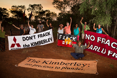
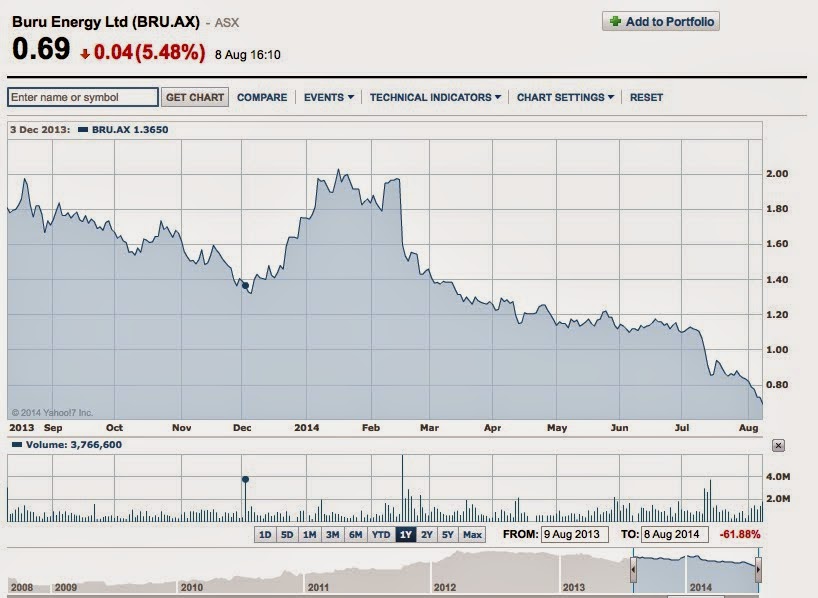
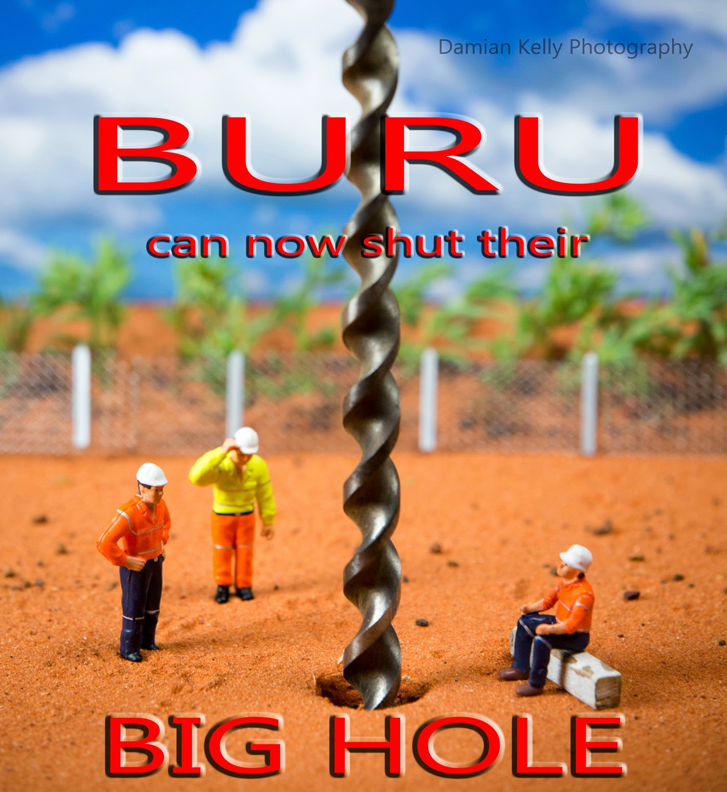
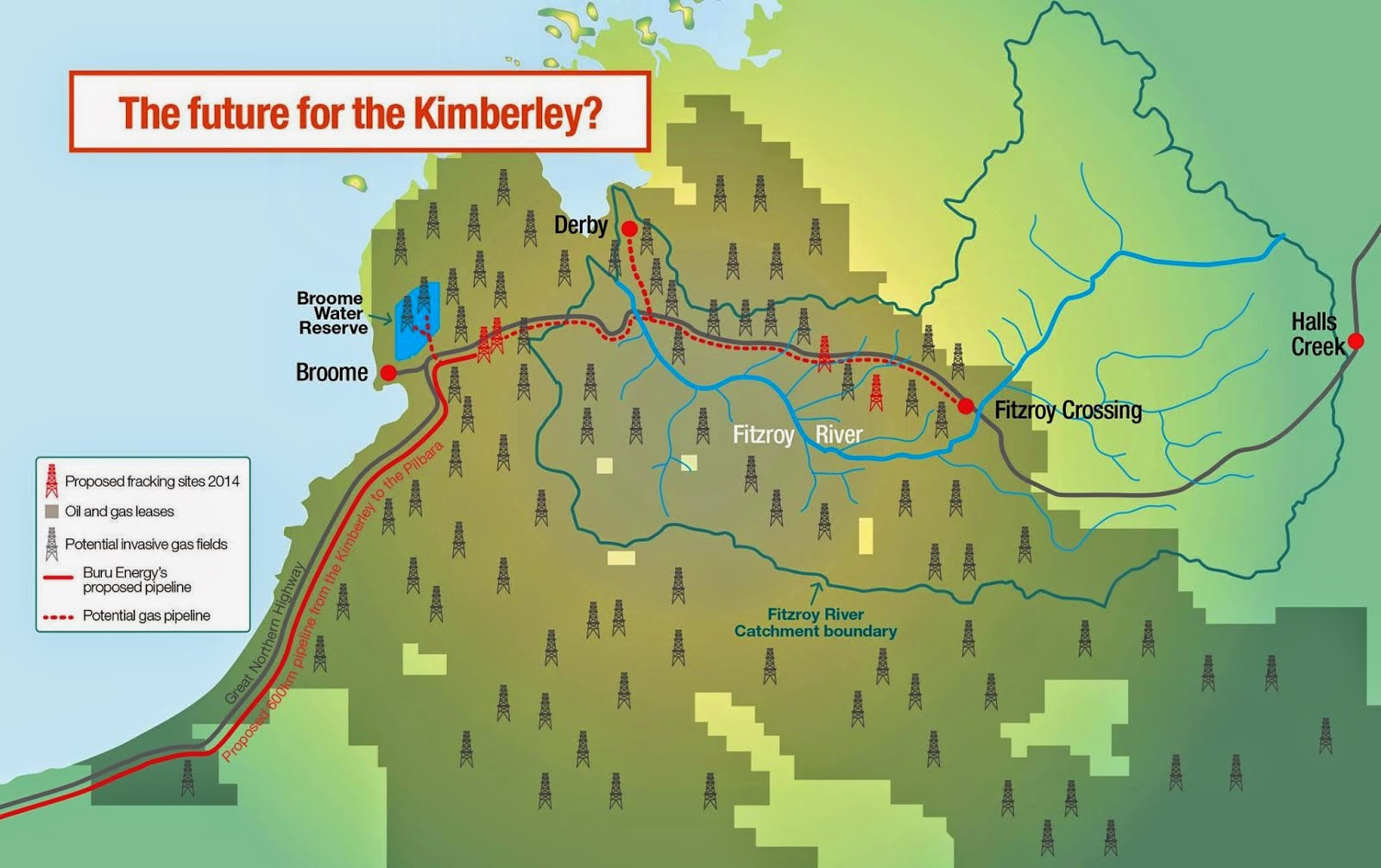

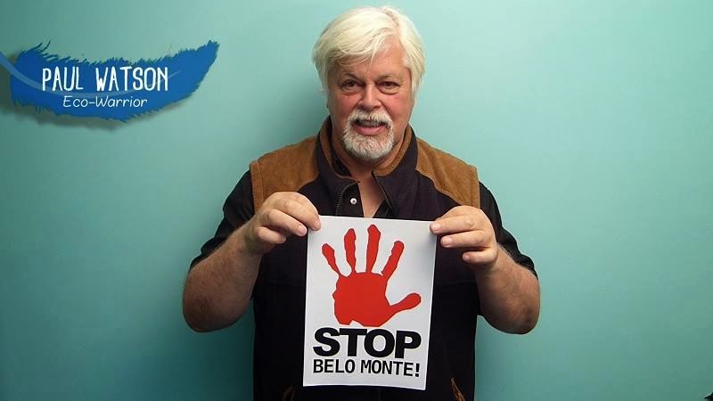
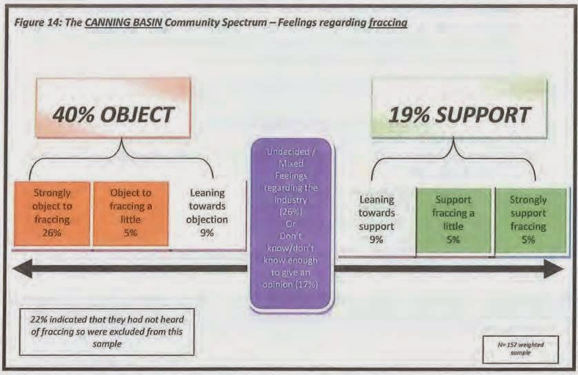
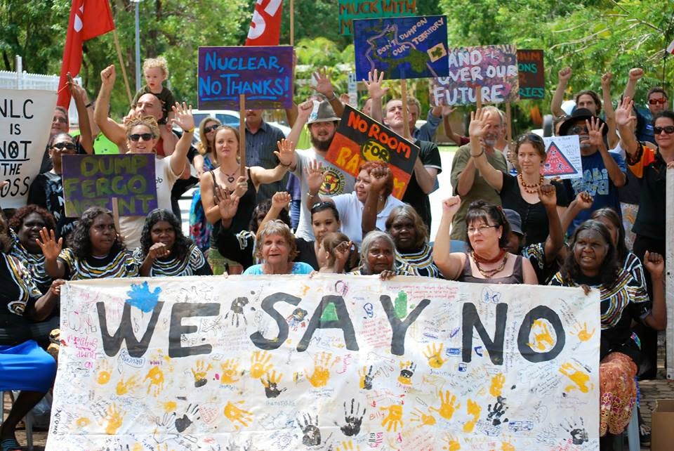


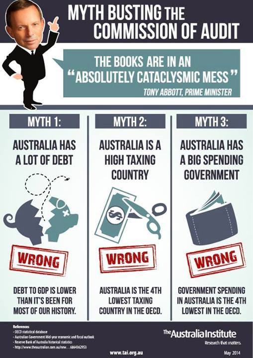
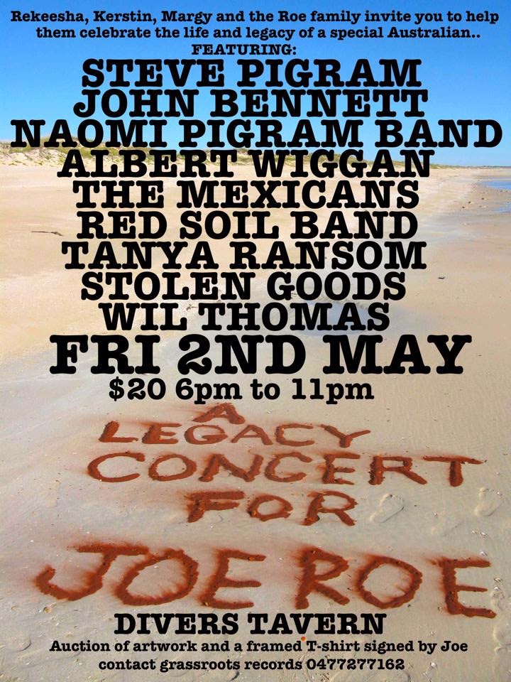

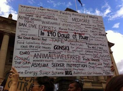
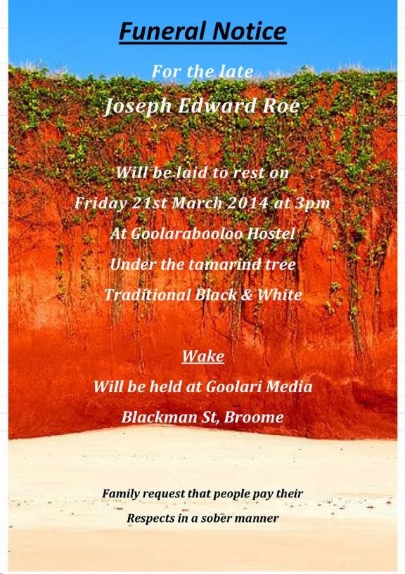

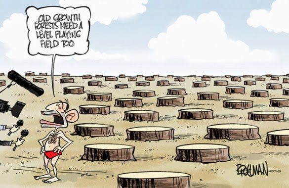
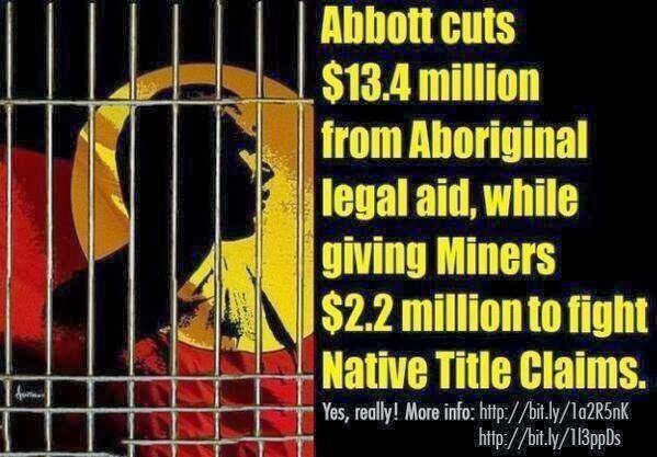
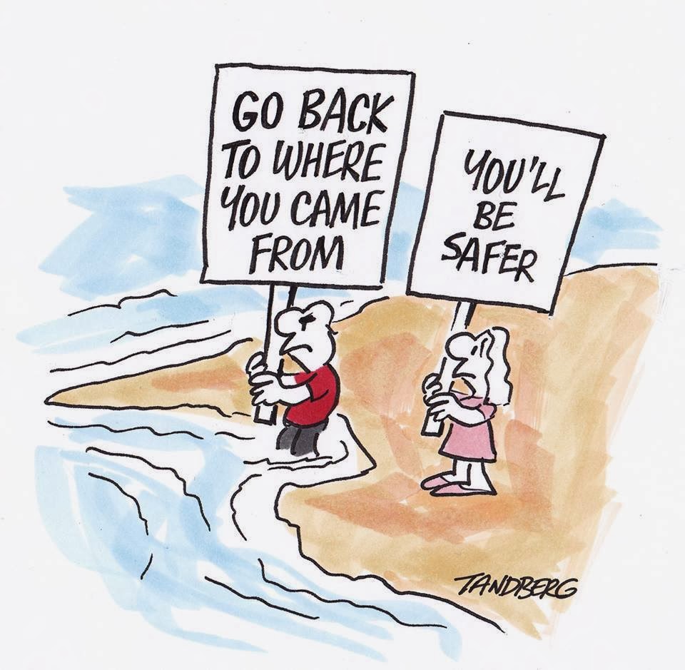

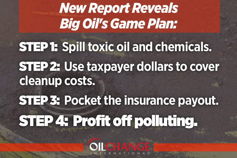
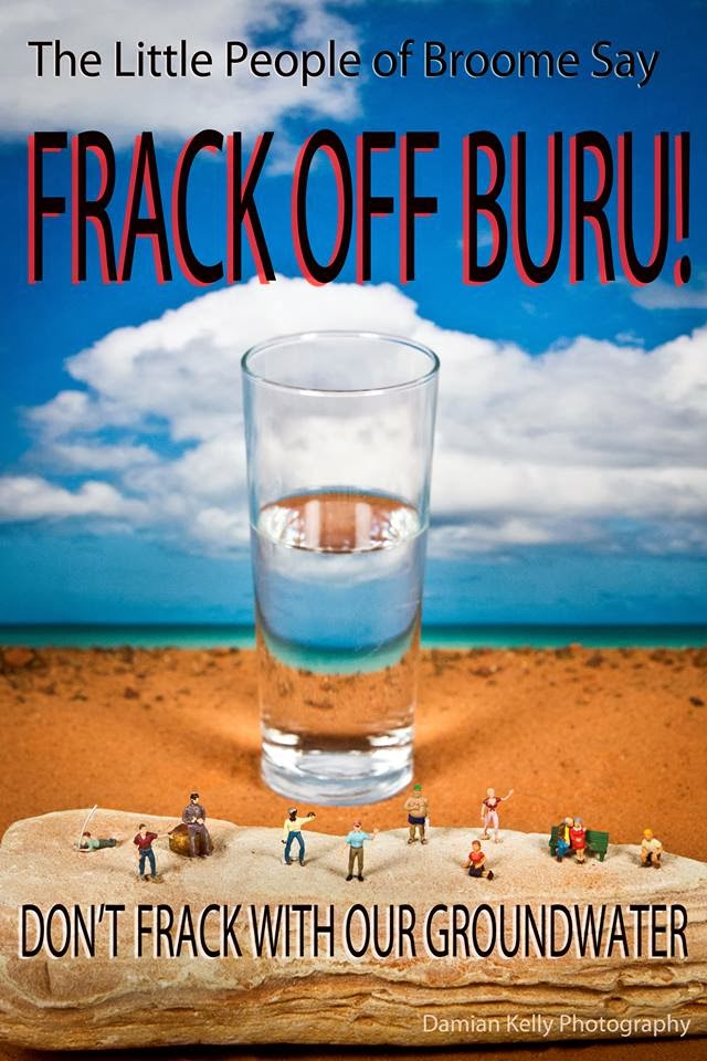

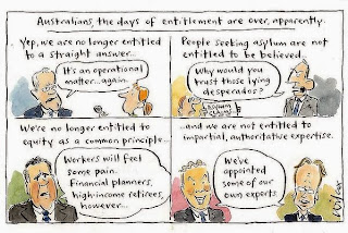
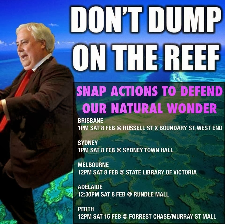


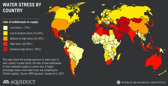
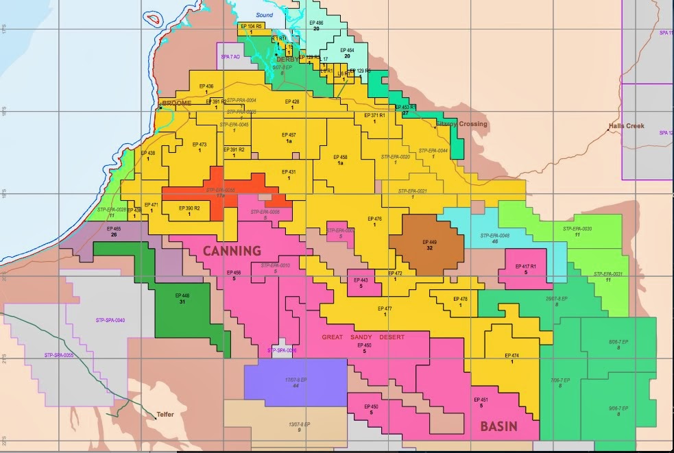

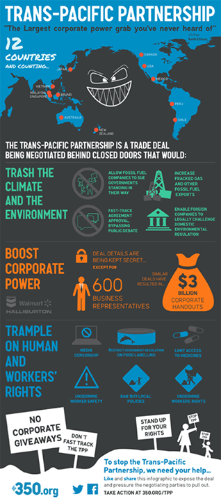


 Photo Damian Kelly

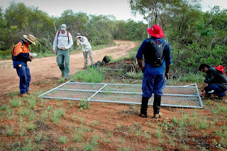


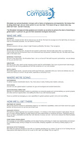


No comments:
Post a Comment